
Topografische Karte Winnipeg
Interaktive Karte
Klicken Sie auf die Karte, um die Höhe anzuzeigen.
Über diese Karte
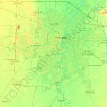
Name: Topografische Karte Winnipeg, Höhe, Relief.
Ort: Winnipeg, Division No. 11, Manitoba, Canada (49.71355 -97.34915 49.99401 -96.95653)
Durchschnittliche Höhe: 236 m
Minimale Höhe: 222 m
Maximale Höhe: 261 m
Winnipeg lies at the bottom of the Red River Valley, a flood plain with an extremely flat topography. It is on the eastern edge of the Canadian Prairies in Western Canada and is known as the "Gateway to the West". Winnipeg is bordered by tallgrass prairie to the west and south and the aspen parkland to the northeast, although most of the native prairie grasses have been removed for agriculture and urbanization. It is relatively close to many large Canadian Shield lakes and parks, as well as Lake Winnipeg (the Earth's 11th largest freshwater lake). Winnipeg has North America's largest extant mature urban elm forest. The city has an area of 464.08 km2 (179.18 sq mi).
Andere topografische Karten
Klicken Sie auf eine Karte, um ihre Topografie, ihre Höhe und ihr Relief anzuzeigen.
Charleswood--St. James--Assiniboia--Headingley
Canada > Manitoba > Division No. 11 > Winnipeg
Charleswood--St. James--Assiniboia--Headingley, Winnipeg, Rural Municipality of Headingley, Division No. 11, Manitoba, Canada
Durchschnittliche Höhe: 238 m
South Portage
Canada > Manitoba > Division No. 11 > Winnipeg
South Portage, Fort Rouge–East Fort Garry, Winnipeg, Division No. 11, Manitoba, Canada
Durchschnittliche Höhe: 235 m
Munson Park
Canada > Manitoba > Division No. 11 > Winnipeg
Munson Park, Crescentwood, Winnipeg, Division No. 11, Manitoba, Canada
Durchschnittliche Höhe: 236 m
Victoria Jason Park
Canada > Manitoba > Division No. 11 > Winnipeg
Victoria Jason Park, Kildare–Redonda, Winnipeg, Division No. 11, Manitoba, Canada
Durchschnittliche Höhe: 235 m
Seine River
Canada > Manitoba > Division No. 11 > Winnipeg
Seine River, Dufresne, Winnipeg, Division No. 11, Manitoba, R2H 0V4, Canada
Durchschnittliche Höhe: 233 m
Assiniboine River
Canada > Manitoba > Division No. 11 > Winnipeg
Assiniboine River, Assiniboia, Winnipeg, Division No. 11, Manitoba, Canada
Durchschnittliche Höhe: 238 m
Bridgwater Forest
Canada > Manitoba > Division No. 11 > Winnipeg
Bridgwater Forest, Waverley West, Winnipeg, Division No. 11, Manitoba, Canada
Durchschnittliche Höhe: 234 m
Confusion Corner
Canada > Manitoba > Division No. 11 > Winnipeg
Confusion Corner, Osborne Village, McMillan, Fort Rouge–East Fort Garry, Winnipeg, Division No. 11, Manitoba, R3L 1Z6, Canada
Durchschnittliche Höhe: 234 m
Assiniboine Park
Canada > Manitoba > Division No. 11 > Winnipeg
Assiniboine Park, Saint James, Winnipeg, Division No. 11, Manitoba, Canada
Durchschnittliche Höhe: 237 m