
Topografische Karte Whidbey Island
Interaktive Karte
Klicken Sie auf die Karte, um die Höhe anzuzeigen.
Über diese Karte
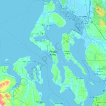
Name: Topografische Karte Whidbey Island, Höhe, Relief.
Ort: Whidbey Island, Island County, Washington, United States (47.90492 -122.76999 48.41132 -122.34936)
Durchschnittliche Höhe: 45 m
Minimale Höhe: -4 m
Maximale Höhe: 993 m
Whidbey Island lies partially in the rain shadow of the Olympic Mountain Range to the west, and has a variety of climate zones. This can be observed by rainfall amounts – wettest in the south with average rainfall of 36 inches (910 mm), driest in the central district of Coupeville with average rainfall of 20 to 22 inches (510 to 560 mm), and turning moister again farther north with average rainfall of 32 inches (810 mm). Microclimates abound, determined by proximity to water, elevation and prevailing winds.
Andere topografische Karten
Klicken Sie auf eine Karte, um ihre Topografie, ihre Höhe und ihr Relief anzuzeigen.
Oak Harbor
United States > Washington > Island County
Oak Harbor, Island County, Washington, United States
Durchschnittliche Höhe: 31 m
Keystone
United States > Washington > Island County
Keystone, Island County, Washington, United States
Durchschnittliche Höhe: 2 m
Clinton
United States > Washington > Island County
Clinton, Island County, Washington, 98236, United States
Durchschnittliche Höhe: 48 m
San de Fuca
United States > Washington > Island County
San de Fuca, Island County, Washington, United States
Durchschnittliche Höhe: 31 m
Glendale
United States > Washington > Island County
Glendale, Island County, Washington, 98275, United States
Durchschnittliche Höhe: 44 m
Cornet
United States > Washington > Island County
Cornet, Island County, Washington, United States
Durchschnittliche Höhe: 54 m
Maxwelton
United States > Washington > Island County
Maxwelton, Island County, Washington, United States
Durchschnittliche Höhe: 27 m
Mabana
United States > Washington > Island County
Mabana, Island County, Washington, United States
Durchschnittliche Höhe: 23 m
Bayview
United States > Washington > Island County
Bayview, Island County, Washington, 98260, United States
Durchschnittliche Höhe: 47 m
Baby Island Heights
United States > Washington > Island County
Baby Island Heights, Island County, Washington, United States
Durchschnittliche Höhe: 19 m
Langley
United States > Washington > Island County
Langley, Island County, Washington, United States
Durchschnittliche Höhe: 48 m
Camano Island
United States > Washington > Island County
Camano Island, Island County, Washington, 98282, United States
Durchschnittliche Höhe: 27 m
Camano
United States > Washington > Island County
Camano, Island County, Washington, 98282, United States
Durchschnittliche Höhe: 31 m
Puget Sound
United States > Washington > Island County
Puget Sound, Island County, Washington, United States
Durchschnittliche Höhe: 0 m
Libbey Beach County Park
United States > Washington > Island County
Libbey Beach County Park, Island County, Washington, United States
Durchschnittliche Höhe: 21 m
Freeland
United States > Washington > Island County
Freeland, Island County, Washington, 98249, United States
Durchschnittliche Höhe: 37 m
Coupeville
United States > Washington > Island County
Coupeville, Island County, Washington, United States
Durchschnittliche Höhe: 27 m
Clinton
United States > Washington > Island County > Clinton
Clinton, Island County, Washington, United States
Durchschnittliche Höhe: 33 m
Long Beach
United States > Washington > Island County > Long Beach
Long Beach, Island County, Washington, 98282, United States
Durchschnittliche Höhe: 11 m
Coupeville, Washington
United States > Washington > Island County
Coupeville, Washington, Island County, Washington, United States
Durchschnittliche Höhe: 29 m
Greenbank
United States > Washington > Island County
Greenbank, Island County, Washington, 98253, United States
Durchschnittliche Höhe: 39 m
Fort Casey
United States > Washington > Island County
Fort Casey, South Fort Casey Road, Island County, Washington, United States
Durchschnittliche Höhe: 1 m