
Topografische Karte Albuquerque
Interaktive Karte
Klicken Sie auf die Karte, um die Höhe anzuzeigen.
Über diese Karte
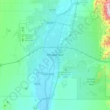
Name: Topografische Karte Albuquerque, Höhe, Relief.
Ort: Albuquerque, Bernalillo County, New Mexico, United States (34.94709 -106.88215 35.21820 -106.47063)
Durchschnittliche Höhe: 1.688 m
Minimale Höhe: 1.490 m
Maximale Höhe: 3.245 m
Located in north-central New Mexico, Albuquerque serves as the county seat of Bernalillo County. To its east are the Sandia–Manzano Mountains, Rio Grande flows north to south through its center, while the West Mesa and Petroglyph National Monument make up the western part of the city. Albuquerque has one of the highest elevations of any major city in the U.S., ranging from 4,900 feet (1,500 m) above sea level near the Rio Grande to over 6,700 feet (2,000 m) in the foothill areas of Sandia Heights and Glenwood Hills. The civic apex is found in an undeveloped area within the Albuquerque Open Space; there, the terrain rises to an elevation of approximately 6,880 feet (2,100 m), and the metropolitan area's highest point is the Sandia Mountains crest at an altitude of 10,678 feet (3,255 m).
Andere topografische Karten
Klicken Sie auf eine Karte, um ihre Topografie, ihre Höhe und ihr Relief anzuzeigen.
Tijeras
United States > New Mexico > Bernalillo County
Tijeras, Bernalillo County, New Mexico, 87509, United States
Durchschnittliche Höhe: 2.038 m
Miera
United States > New Mexico > Bernalillo County
Miera, Bernalillo County, New Mexico, 87196, United States
Durchschnittliche Höhe: 2.232 m
South Valley
United States > New Mexico > Bernalillo County
South Valley, Bernalillo County, New Mexico, 87105, United States
Durchschnittliche Höhe: 1.519 m
Monte Largo Hills
United States > New Mexico > Bernalillo County > Albuquerque
Monte Largo Hills, Albuquerque, Bernalillo County, New Mexico, 87112, United States
Durchschnittliche Höhe: 1.817 m
Albuquerque
United States > New Mexico > Bernalillo County > Albuquerque
Albuquerque, Bernalillo County, New Mexico, 87102, United States
Durchschnittliche Höhe: 1.671 m
Sandia Park
United States > New Mexico > Bernalillo County
Sandia Park, Bernalillo County, New Mexico, 87008, United States
Durchschnittliche Höhe: 2.198 m
Sandia Heights
United States > New Mexico > Bernalillo County > Albuquerque
Sandia Heights, Albuquerque, Bernalillo County, New Mexico, 87122, United States
Durchschnittliche Höhe: 1.898 m
Monticello
United States > New Mexico > Bernalillo County
Monticello, Bernalillo County, New Mexico, United States
Durchschnittliche Höhe: 1.949 m
Sandia Crest
United States > New Mexico > Bernalillo County
Sandia Crest, Bernalillo County, New Mexico, United States
Durchschnittliche Höhe: 2.925 m
Rio Grande
United States > New Mexico > Bernalillo County > South Valley
Rio Grande, Kinney, South Valley, Bernalillo County, New Mexico, 87105, United States
Durchschnittliche Höhe: 1.504 m
Embudo Canyon
United States > New Mexico > Bernalillo County > Albuquerque
Embudo Canyon, Albuquerque, Bernalillo County, New Mexico, 87112, United States
Durchschnittliche Höhe: 1.858 m
Glenwood Hills
United States > New Mexico > Bernalillo County > Albuquerque
Glenwood Hills, Albuquerque, Bernalillo County, New Mexico, 87111, United States
Durchschnittliche Höhe: 1.937 m
Joe M. Lucero Hillside
United States > New Mexico > Bernalillo County > Albuquerque
Joe M. Lucero Hillside, Albuquerque, Bernalillo County, New Mexico, United States
Durchschnittliche Höhe: 1.637 m