
Topografische Karte Sukma
Interaktive Karte
Klicken Sie auf die Karte, um die Höhe anzuzeigen.
Sukma
This place can easily be a matter of research for the Archaeological department as there exists rare ancient sculptures in this area, one can see a sculpture on which Brahma,Vishnu and Mahesh the Trinity of Hindu faith can be seen on a single stone. Now with the elevation of this area into a new District people are hopeful that Archaeological department will start researching in this area and unveil the historical importance of the land to the outer world.
Über diese Karte
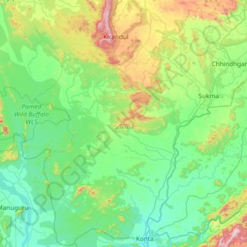
Name: Topografische Karte Sukma, Höhe, Relief.
Ort: Sukma, Chhattisgarh, India (17.78222 80.91126 18.77433 81.96794)
Durchschnittliche Höhe: 256 m
Minimale Höhe: 31 m
Maximale Höhe: 1.340 m
Andere topografische Karten
Klicken Sie auf eine Karte, um ihre Topografie, ihre Höhe und ihr Relief anzuzeigen.
Kharsia
India > Chhattisgarh > Kharsia Tahsil
Kharsia is located at 21°58′N 83°07′E / 21.97°N 83.12°E / 21.97; 83.12. It has an average elevation of 245 m (804 ft).
Durchschnittliche Höhe: 253 m
Balod
India > Chhattisgarh > Balod Tahsil
Balod is located at 20°44′N 81°12′E / 20.73°N 81.2°E / 20.73; 81.2. It has an average elevation of 324 metres (1063 feet).
Durchschnittliche Höhe: 323 m
Kanker
India > Chhattisgarh > Kanker Tahsil
Kanker is located at 20°16′N 81°29′E / 20.27°N 81.49°E / 20.27; 81.49. It has an average elevation of 388 metres (1272 feet).
Durchschnittliche Höhe: 405 m
Kanker
India > Chhattisgarh > Kanker Tahsil
Kanker is located at 20°16′N 81°29′E / 20.27°N 81.49°E / 20.27; 81.49. It has an average elevation of 388 metres (1272 feet).
Durchschnittliche Höhe: 405 m
Raigarh
India > Chhattisgarh > Raigarh Tahsil
Raigarh is located at 21°54′N 83°24′E / 21.9°N 83.4°E / 21.9; 83.4. It has an average elevation of 215 metres (705 feet). The Kelo river flows through the city, which is one of its main water sources.
Durchschnittliche Höhe: 216 m
Gariaband
India > Chhattisgarh > Bindranavagarh(Gariyaband) Tahsil
Gariaband is Loceted on 20°38′N 82°03′E / 20.63°N 82.05°E / 20.63; 82.05. Gariaband has an average elevation of 318 metres (1043 ft).
Durchschnittliche Höhe: 346 m
Kanker
India > Chhattisgarh > Kanker Tahsil
Kanker is located at 20°16′N 81°29′E / 20.27°N 81.49°E / 20.27; 81.49. It has an average elevation of 388 metres (1272 feet).
Durchschnittliche Höhe: 405 m
Sukma
India > Chhattisgarh > Sukma Tahsil
It is located at 18°24′0″N 81°40′0″E / 18.40000°N 81.66667°E / 18.40000; 81.66667 at an elevation of 210 m above MSL.
Durchschnittliche Höhe: 219 m
Champa
India > Chhattisgarh > Champa Tahsil
Champa has an average elevation of 253 metres (830 feet). It is located on the banks of Hasdeo river, a tributary of Mahanadi.
Durchschnittliche Höhe: 254 m
Kapsi
India > Chhattisgarh > Pakhanjur Tahsil
Geographically, it lies in the northern lowlands of the Bastar plateau and is a part of the historical Dandakaranya region. The elevation of the village ranges from 310 m (1,020 ft) to 330 m (1,080 ft) above sea level. The Devda ravine, a tributary of Kotri river, meanders through the heart of the village and…
Durchschnittliche Höhe: 325 m
Balodabazar
India > Chhattisgarh > Baloda Bazar Tahsil
Baloda Bazar is located at 30°40′N 82°10′E / 30.67°N 82.17°E / 30.67; 82.17. It has an average elevation of 254 m (833 ft). There are several tourist places in Balodabazaar like Sirpur, Turturia, Giroudpuri, Siddheswr Mandir Pallari and many more.
Durchschnittliche Höhe: 251 m
Bhilai
India > Chhattisgarh > Durg Tahsil
Bhilai lies at 21.21°N 81.38°E in Central India at an elevation of 297m above sea level on the banks of the Shivnath river, a tributary of the river Mahanadi. It covers an area of 341 km2 (132 sq mi).
Durchschnittliche Höhe: 292 m
Kirandul
India > Chhattisgarh > Kuakonda Tahsil
The Kothavalasa–Kirandul line of East Coast Railway from Kirandul to Visakhapatnam via Koraput is laid through the Eastern Ghats. Up to Araku station, it has many tunnels. Also it pass through the highest elevation Broad gauge station in the Eastern ghats, Semiliguda, just before the Borra caves. Kirandul -…
Durchschnittliche Höhe: 742 m
Pendra
India > Chhattisgarh > Pendra Tahsil
Pendra has an average elevation of 617 metres (2,024 ft).
Durchschnittliche Höhe: 594 m
Bhatpara
India > Chhattisgarh > Bhatpara
Bhatpara is located at 22°52′N 88°25′E / 22.87°N 88.41°E / 22.87; 88.41. It has an average elevation of 12 metres (39 feet). The main town is sandwiched between the Hoogly river in the west and railway track linking Sealdah and Krishnanagar in the east.
Durchschnittliche Höhe: 264 m