Geolokalisieren

Topografische Karte Gonzales County

Interaktive Karte

Klicken Sie auf die Karte, um die Höhe anzuzeigen.

Über diese Karte

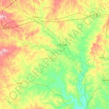
Name: Topografische Karte Gonzales County, Höhe, Relief.

Ort: Gonzales County, Texas, United States (29.11038 -97.85877 29.78464 -97.13053)

Durchschnittliche Höhe: 114 m

Minimale Höhe: 51 m

Maximale Höhe: 230 m

Andere topografische Karten

Klicken Sie auf eine Karte, um ihre Topografie, ihre Höhe und ihr Relief anzuzeigen.

Spring Branch

United States > Texas > Comal County

Durchschnittliche Höhe: 348 m

Canyon Lake

United States > Texas > Comal County

Durchschnittliche Höhe: 296 m

San Antonio

United States > Texas > Bexar County > San Antonio

Durchschnittliche Höhe: 218 m

Kingwood

United States > Texas > Harris County > Houston

Durchschnittliche Höhe: 22 m

Dallas

United States > Texas > Dallas County

Dallas and its surrounding area are mostly flat. The city lies at elevations ranging from 450 to 550 feet (137 to 168 m) above sea level. The western edge of the Austin Chalk Formation, a limestone escarpment (also known as the "White Rock Escarpment"), rises 230 feet (70 m) and runs roughly north–south…

Durchschnittliche Höhe: 158 m

Bryan

United States > Texas > Brazos County > Bryan

Durchschnittliche Höhe: 89 m

Horseshoe Bay

United States > Texas > Llano County > Horseshoe Bay > Horseshoe Bay

Durchschnittliche Höhe: 286 m

Bulverde

United States > Texas > Comal County

Durchschnittliche Höhe: 364 m

Center Point

United States > Texas > Parker County

Durchschnittliche Höhe: 293 m

Nurse

United States > Texas > Erath County > Stephenville

Durchschnittliche Höhe: 405 m

Doucette

United States > Texas > Tyler County

Durchschnittliche Höhe: 96 m

Emory Peak

United States > Texas > Brewster County

The peak can be reached by a moderate hike on a well-marked path across steep rocky terrain with an elevation gain of approximately 2,500 feet (760 m). The Emory Peak Trail is about 1.5 miles (2.4 km) long. The trail is reached by climbing the Pinnacles Trail 3.5 miles (5.6 km) from the Chisos Basin trailhead.…

Durchschnittliche Höhe: 2.061 m

Shannon

United States > Texas > Clay County

Durchschnittliche Höhe: 321 m

Naruna

United States > Texas > Burnet County

Durchschnittliche Höhe: 445 m

New Salem

United States > Texas > Palo Pinto County

Durchschnittliche Höhe: 263 m

Las Palmas

United States > Texas > Zapata County

Durchschnittliche Höhe: 138 m

Blossom

United States > Texas > Lamar County

Durchschnittliche Höhe: 166 m

New Braunfels

United States > Texas > Comal County

Durchschnittliche Höhe: 228 m

Guadalupe Peak

United States > Texas > Culberson County

Guadalupe Peak, also known as Signal Peak, is the highest natural point in Texas, with an elevation of 8,751 feet (2,667 m) above sea level. It is located in Guadalupe Mountains National Park, and is part of the Guadalupe Mountains range in southeastern New Mexico and West Texas. The mountain is about 90 miles…

Durchschnittliche Höhe: 2.150 m

Port O'Connor

United States > Texas > Calhoun County

Durchschnittliche Höhe: 3 m

Palmview

United States > Texas > Hidalgo County

Durchschnittliche Höhe: 43 m

Desdemona

United States > Texas > Eastland County

Durchschnittliche Höhe: 422 m

Eastwoods Neighborhood Park

United States > Texas > Travis County > Austin

Durchschnittliche Höhe: 182 m

Clear Lake City

United States > Texas > Harris County > Houston

Durchschnittliche Höhe: 8 m

Call

United States > Texas > Newton County

Durchschnittliche Höhe: 32 m

Kenney

United States > Texas > Austin County

Durchschnittliche Höhe: 102 m

Columbus

United States > Texas > Colorado County

Durchschnittliche Höhe: 61 m

Jacksonville

United States > Texas > Cherokee County

Durchschnittliche Höhe: 152 m

Weatherford

United States > Texas > Parker County

Durchschnittliche Höhe: 326 m

Pinehurst

United States > Texas > Montgomery County

Durchschnittliche Höhe: 67 m

Austin

United States > Texas > Travis County

The elevation of Austin varies from 425 feet (130 m) to approximately 1,000 feet (305 m) above sea level. Due to the fact it straddles the Balcones Fault, much of the eastern part of the city is flat, with heavy clay and loam soils, whereas the western part and western suburbs consist of rolling hills on the…

Durchschnittliche Höhe: 203 m

Sewell Park

United States > Texas > Hays County > San Marcos

Durchschnittliche Höhe: 192 m

New Caney

United States > Texas > Montgomery County

Durchschnittliche Höhe: 30 m

Brazos

United States > Texas > Palo Pinto County

Durchschnittliche Höhe: 255 m

Terrell

United States > Texas > Kaufman County

Durchschnittliche Höhe: 153 m

Singleton

United States > Texas > Grimes County

Durchschnittliche Höhe: 104 m

Cranes Mill

United States > Texas > Comal County

Durchschnittliche Höhe: 308 m

Pecan Grove

United States > Texas > Fort Bend County

Durchschnittliche Höhe: 27 m

Happy Valley

United States > Texas > Nacogdoches County

Durchschnittliche Höhe: 113 m

Cresson

United States > Texas > Hood County

Durchschnittliche Höhe: 303 m

Theon

United States > Texas > Williamson County

Durchschnittliche Höhe: 256 m

Bassett

United States > Texas > Bowie County

Durchschnittliche Höhe: 80 m

Boomtown

United States > Texas > Tarrant County > Arlington

Durchschnittliche Höhe: 170 m

Concepcion Park

United States > Texas > Bexar County > San Antonio

Durchschnittliche Höhe: 189 m

Menard Park

United States > Texas > Galveston County > Galveston

Durchschnittliche Höhe: 4 m

Joppa

United States > Texas > Burnet County

Durchschnittliche Höhe: 342 m

Doug Russell Park

United States > Texas > Tarrant County > Arlington

Durchschnittliche Höhe: 191 m

Moonshine Hill

United States > Texas > Harris County > Houston

Durchschnittliche Höhe: 22 m

Smith

United States > Texas > Bell County > Temple

Durchschnittliche Höhe: 192 m

Marfa

United States > Texas > Presidio County

Marfa is a city in the high desert of the Trans-Pecos in far West Texas, United States, between the Davis Mountains and Big Bend National Park, at an elevation of 4685 feet. It is the county seat of Presidio County, and its population as of the 2020 United States Census was 1,788. The city was founded in the…

Durchschnittliche Höhe: 1.434 m

Hagansport

United States > Texas > Franklin County

Durchschnittliche Höhe: 113 m

Eddy

United States > Texas > McLennan County > Bruceville-Eddy

Durchschnittliche Höhe: 211 m

Sandusky

United States > Texas > Grayson County

Durchschnittliche Höhe: 220 m

Blanco State Park

United States > Texas > Blanco County > Blanco

Durchschnittliche Höhe: 417 m

Indian Creek

United States > Texas > Fannin County > Trenton

Durchschnittliche Höhe: 230 m

Tripp

United States > Texas > Dallas County > Sunnyvale

Durchschnittliche Höhe: 143 m

Catarina

United States > Texas > Dimmit County

Durchschnittliche Höhe: 157 m

Purdue Lake Dam

United States > Texas > Fannin County

Durchschnittliche Höhe: 202 m

Vanderpool

United States > Texas > Bandera County

Durchschnittliche Höhe: 524 m

Godley

United States > Texas > Johnson County

Durchschnittliche Höhe: 287 m

Tracy

United States > Texas > Milam County

Durchschnittliche Höhe: 130 m

The Cove

United States > Texas > Tarrant County > Grand Prairie

Durchschnittliche Höhe: 164 m

Buckner

United States > Texas > Collin County > McKinney

Durchschnittliche Höhe: 197 m

Bentsen Colonia

United States > Texas > Hidalgo County > McAllen

Durchschnittliche Höhe: 38 m

Shepard Hill

United States > Texas > Montgomery County

Durchschnittliche Höhe: 86 m

Blessing

United States > Texas > Matagorda County

Durchschnittliche Höhe: 13 m

Lazy River

United States > Texas > Montgomery County > The Woodlands > Wild Ridge

Durchschnittliche Höhe: 44 m

Alamo Beach

United States > Texas > Calhoun County

Durchschnittliche Höhe: 2 m

Doc Brown

United States > Texas > Orange County > West Orange

Durchschnittliche Höhe: 5 m

Graham

United States > Texas > Young County

Durchschnittliche Höhe: 332 m

Chimney Rock Park

United States > Texas > Harris County > Houston

Durchschnittliche Höhe: 21 m

Dicey

United States > Texas > Parker County

Durchschnittliche Höhe: 296 m

Flower Mountain

United States > Texas > Nacogdoches County

Durchschnittliche Höhe: 183 m

Enchanted Rock

United States > Texas > Llano County

Enchanted Rock is a pink granite mountain located in the Llano Uplift about 17 miles (27 km) north of Fredericksburg, Texas and 24 miles (39 km) south of Llano, Texas, United States. Enchanted Rock State Natural Area, which includes Enchanted Rock and surrounding land, spans the border between Gillespie and…

Durchschnittliche Höhe: 453 m

Fosters Mill

United States > Texas > Harris County > Houston

Durchschnittliche Höhe: 21 m

Calvary

United States > Texas > Wood County

Durchschnittliche Höhe: 132 m

Agua Dulce

United States > Texas > El Paso County

Durchschnittliche Höhe: 1.225 m

Klein

United States > Texas > Harris County

Durchschnittliche Höhe: 43 m

Boz

United States > Texas > Ellis County

Durchschnittliche Höhe: 194 m

Tavener

United States > Texas > Fort Bend County

Durchschnittliche Höhe: 36 m

Love's Lookout Park

United States > Texas > Cherokee County

Durchschnittliche Höhe: 171 m

Penwell

United States > Texas > Ector County

Durchschnittliche Höhe: 899 m

Guadalupe River

United States > Texas > Kerr County > Kerrville

Durchschnittliche Höhe: 510 m

Segovia

United States > Texas > Kimble County

Durchschnittliche Höhe: 573 m

Caplen

United States > Texas > Galveston County

Durchschnittliche Höhe: 1 m

Heights

United States > Texas > Galveston County > Texas City

Durchschnittliche Höhe: 5 m

Junction

United States > Texas > Kimble County

Durchschnittliche Höhe: 532 m

McMahan

United States > Texas > Caldwell County

Durchschnittliche Höhe: 147 m

Renner

United States > Texas > Collin County > Dallas

Durchschnittliche Höhe: 206 m

Townewest

United States > Texas > Fort Bend County

Durchschnittliche Höhe: 28 m

Dallas County

United States > Texas

Durchschnittliche Höhe: 182 m

Cleburne

United States > Texas > Johnson County

Durchschnittliche Höhe: 250 m

Hudson

United States > Texas > Harris County > Houston

Durchschnittliche Höhe: 31 m

Wylie

United States > Texas > Taylor County > Abilene

Durchschnittliche Höhe: 552 m

Cat Spring

United States > Texas > Austin County

Durchschnittliche Höhe: 90 m