
Topografische Karte Pero Pinheiro
Interaktive Karte
Klicken Sie auf die Karte, um die Höhe anzuzeigen.
Über diese Karte
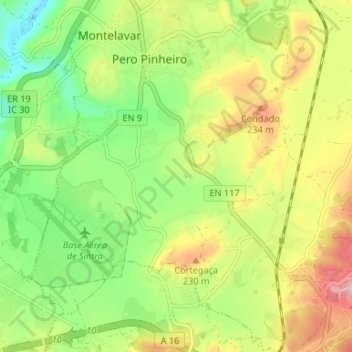
Name: Topografische Karte Pero Pinheiro, Höhe, Relief.
Durchschnittliche Höhe: 160 m
Minimale Höhe: 55 m
Maximale Höhe: 301 m
Andere topografische Karten
Klicken Sie auf eine Karte, um ihre Topografie, ihre Höhe und ihr Relief anzuzeigen.
Montelavar
Portugal > Lisboa > Almargem do Bispo, Pêro Pinheiro e Montelavar
Montelavar, Almargem do Bispo, Pêro Pinheiro e Montelavar, Sintra, Lisboa, 2715-085, Portugal
Durchschnittliche Höhe: 155 m
Negrais
Portugal > Lisboa > Almargem do Bispo, Pêro Pinheiro e Montelavar
Negrais, Almargem do Bispo, Pêro Pinheiro e Montelavar, Sintra, Lisboa, 2715-343, Portugal
Durchschnittliche Höhe: 214 m
Morelena
Portugal > Lisboa > Almargem do Bispo, Pêro Pinheiro e Montelavar > Pero Pinheiro
Morelena, Pero Pinheiro, Almargem do Bispo, Pêro Pinheiro e Montelavar, Sintra, Lisboa, 2715-061, Portugal
Durchschnittliche Höhe: 167 m
Olelas
Portugal > Lisboa > Almargem do Bispo, Pêro Pinheiro e Montelavar > Almargem do Bispo
Olelas, Almargem do Bispo, Almargem do Bispo, Pêro Pinheiro e Montelavar, Sintra, Lisboa, 2715-398, Portugal
Durchschnittliche Höhe: 224 m