
Topografische Karte Cottles Bridge
Interaktive Karte
Klicken Sie auf die Karte, um die Höhe anzuzeigen.
Über diese Karte
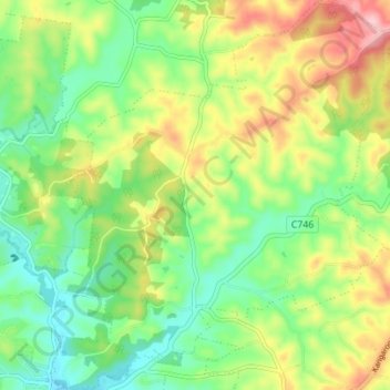
Name: Topografische Karte Cottles Bridge, Höhe, Relief.
Durchschnittliche Höhe: 143 m
Minimale Höhe: 72 m
Maximale Höhe: 254 m
Andere topografische Karten
Klicken Sie auf eine Karte, um ihre Topografie, ihre Höhe und ihr Relief anzuzeigen.
Panton Hill
Australia > Victoria > Panton Hill
Panton Hill, Shire of Nillumbik, Victoria, 3759, Australia
Durchschnittliche Höhe: 150 m
Panton Hill
Australia > Victoria > Panton Hill
Panton Hill, Shire of Nillumbik, Victoria, 3759, Australia
Durchschnittliche Höhe: 152 m