
Topografische Karte Espiniella
Interaktive Karte
Klicken Sie auf die Karte, um die Höhe anzuzeigen.
Über diese Karte
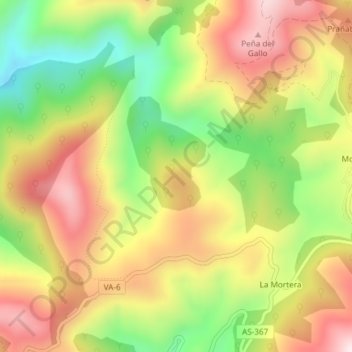
Name: Topografische Karte Espiniella, Höhe, Relief.
Ort: Espiniella, Valdés, Asturias, España (43.49423 -6.36903 43.51423 -6.34903)
Durchschnittliche Höhe: 424 m
Minimale Höhe: 165 m
Maximale Höhe: 667 m
Andere topografische Karten
Klicken Sie auf eine Karte, um ihre Topografie, ihre Höhe und ihr Relief anzuzeigen.
Monte Faro
Monte Faro, Valdés, Asturias, 37790, España
Durchschnittliche Höhe: 111 m
Playa de Barayo
Playa de Barayo, Valdés, Asturias, España
Durchschnittliche Höhe: 39 m