
Topografische Karte Disappointment Peak
Interaktive Karte
Klicken Sie auf die Karte, um die Höhe anzuzeigen.
Über diese Karte
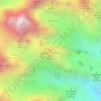
Name: Topografische Karte Disappointment Peak, Höhe, Relief.
Ort: Disappointment Peak, Teton County, Wyoming, United States (43.73323 -110.79247 43.73333 -110.79237)
Durchschnittliche Höhe: 3.255 m
Minimale Höhe: 2.514 m
Maximale Höhe: 4.184 m
Andere topografische Karten
Klicken Sie auf eine Karte, um ihre Topografie, ihre Höhe und ihr Relief anzuzeigen.
Grand Teton National Park
United States > Wyoming > Teton County
Grand Teton National Park, Teton County, Wyoming, United States
Durchschnittliche Höhe: 2.409 m
Teton Village
United States > Wyoming > Teton County
Teton Village, Teton County, Wyoming, 83025, United States
Durchschnittliche Höhe: 2.144 m
Pacific Creek
United States > Wyoming > Teton County
Pacific Creek, Teton County, Wyoming, United States
Durchschnittliche Höhe: 2.434 m
Isa Lake
United States > Wyoming > Teton County
Isa Lake, Teton County, Wyoming, United States
Durchschnittliche Höhe: 2.503 m
Rocky Mountains
United States > Wyoming > Teton County
Rocky Mountains, Teton County, Wyoming, United States
Durchschnittliche Höhe: 2.292 m
Jackson
United States > Wyoming > Teton County
Jackson, Teton County, Wyoming, 83002, United States
Durchschnittliche Höhe: 2.043 m
Moran
United States > Wyoming > Teton County > Moran
Moran, Teton County, Wyoming, United States
Durchschnittliche Höhe: 2.088 m
Upper Geyser Basin
United States > Wyoming > Teton County > Upper Geyser Basin
Upper Geyser Basin, Teton County, Wyoming, United States
Durchschnittliche Höhe: 2.295 m
Buck Mountain
United States > Wyoming > Teton County
Buck Mountain, Teton County, Wyoming, United States
Durchschnittliche Höhe: 3.128 m
Grand Teton
United States > Wyoming > Teton County
Grand Teton, Teton County, Wyoming, United States
Durchschnittliche Höhe: 3.330 m
Yellowstone Lake
United States > Wyoming > Teton County
Yellowstone Lake, Teton County, Wyoming, United States
Durchschnittliche Höhe: 2.453 m