
Topografische Karte Arab
Interaktive Karte
Klicken Sie auf die Karte, um die Höhe anzuzeigen.
Über diese Karte
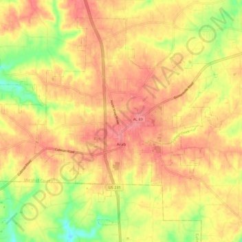
Name: Topografische Karte Arab, Höhe, Relief.
Ort: Arab, Marshall County, Alabama, 35016, United States (34.28777 -86.56015 34.36571 -86.45000)
Durchschnittliche Höhe: 314 m
Minimale Höhe: 266 m
Maximale Höhe: 343 m
According to the U.S. Census Bureau, the city has a total area of 13.1 square miles (34.0 km2), of which 14.0 square miles (36.3 km2) is land and 0.12 square miles (0.3 km2), or 1.02%, is water. The town's elevation is 1,124 feet (343 m) above sea level.
Andere topografische Karten
Klicken Sie auf eine Karte, um ihre Topografie, ihre Höhe und ihr Relief anzuzeigen.
Albertville
United States > Alabama > Marshall County
Albertville, Marshall County, Alabama, 35950, United States
Durchschnittliche Höhe: 309 m
Grassy
United States > Alabama > Marshall County
Grassy, Marshall County, Alabama, United States
Durchschnittliche Höhe: 309 m