
Topografische Karte Murcia
Interaktive Karte
Klicken Sie auf die Karte, um die Höhe anzuzeigen.
Über diese Karte
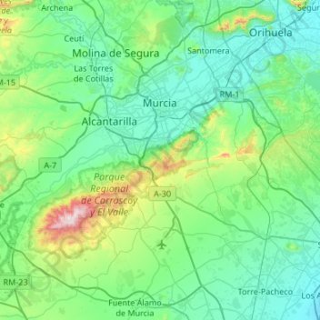
Name: Topografische Karte Murcia, Höhe, Relief.
Ort: Murcia, Área Metropolitana de Murcia, Region of Murcia, Spain (37.71587 -1.38555 38.11792 -0.85089)
Durchschnittliche Höhe: 171 m
Minimale Höhe: 2 m
Maximale Höhe: 1.055 m
Murcia is located near the center of a low-lying fertile plain known as the huerta (orchard or vineyard) of Murcia. The Segura River and its right-hand tributary, the Guadalentín, run through the area. The city has an elevation of 43 metres (141 ft) above sea level and its municipality covers approximately 882 square kilometres (341 sq mi).
Andere topografische Karten
Klicken Sie auf eine Karte, um ihre Topografie, ihre Höhe und ihr Relief anzuzeigen.
Alcantarilla
Spain > Region of Murcia > Área Metropolitana de Murcia
Alcantarilla, Área Metropolitana de Murcia, Region of Murcia, Spain
Durchschnittliche Höhe: 79 m