
Topografische Karte Parres
Interaktive Karte
Klicken Sie auf die Karte, um die Höhe anzuzeigen.
Über diese Karte
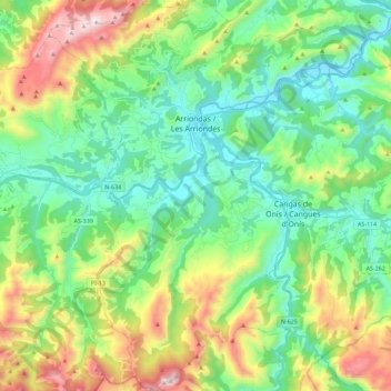
Name: Topografische Karte Parres, Höhe, Relief.
Ort: Parres, Asturias, España (43.27667 -5.26944 43.44079 -5.08548)
Durchschnittliche Höhe: 348 m
Minimale Höhe: 5 m
Maximale Höhe: 1.144 m
Andere topografische Karten
Klicken Sie auf eine Karte, um ihre Topografie, ihre Höhe und ihr Relief anzuzeigen.
Las Dueñas
Las Dueñas, Parres, Asturias, 33550, España
Durchschnittliche Höhe: 412 m
Cuadroveña
España > Asturias > Parres > Arriondas
Cuadroveña, Arriondas, Parres, Asturias, 33540, España
Durchschnittliche Höhe: 125 m