
Topografische Karte Szczawa
Interaktive Karte
Klicken Sie auf die Karte, um die Höhe anzuzeigen.
Über diese Karte
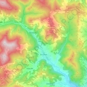
Name: Topografische Karte Szczawa, Höhe, Relief.
Durchschnittliche Höhe: 706 m
Minimale Höhe: 462 m
Maximale Höhe: 1.002 m
Andere topografische Karten
Klicken Sie auf eine Karte, um ihre Topografie, ihre Höhe und ihr Relief anzuzeigen.
Granice
Poland > Lesser Poland Voivodeship > Limanowa County > Sadek
Granice, Sadek, gmina Jodłownik, Limanowa County, Lesser Poland Voivodeship, 34-620, Poland
Durchschnittliche Höhe: 405 m
Korab
Poland > Lesser Poland Voivodeship > Limanowa County > Jaworzna
Korab, Jaworzna, gmina Laskowa, Limanowa County, Lesser Poland Voivodeship, 34-602, Poland
Durchschnittliche Höhe: 593 m
Dobra
Poland > Lesser Poland Voivodeship > Limanowa County > Dobra
Dobra, gmina Dobra, Limanowa County, Lesser Poland Voivodeship, 34-642, Poland
Durchschnittliche Höhe: 578 m
Limanowa
Poland > Lesser Poland Voivodeship > Limanowa County > Limanowa
Limanowa, Limanowa County, Lesser Poland Voivodeship, Poland
Durchschnittliche Höhe: 492 m