
Topografische Karte Drang Drung Glacier
Interaktive Karte
Klicken Sie auf die Karte, um die Höhe anzuzeigen.
Über diese Karte
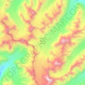
Name: Topografische Karte Drang Drung Glacier, Höhe, Relief.
Durchschnittliche Höhe: 5.098 m
Minimale Höhe: 3.938 m
Maximale Höhe: 6.533 m
The Drang-Drung Glacier is likely to be the largest glacier in Ladakh after the Siachen Glacier in the Karakoram Range, with a maximum length of 23 km (14 mi) at an average elevation of 4,780 m (15,680 ft; 2.97 mi). The glacier lies in the northeastern Himalayan Range known as the Zanskar Range, 142 km (88 mi) south of Kargil and 331 km (206 mi) east of Srinagar, the capital of Jammu and Kashmir.