
Topografische Karte Sonprayag
Interaktive Karte
Klicken Sie auf die Karte, um die Höhe anzuzeigen.
Über diese Karte
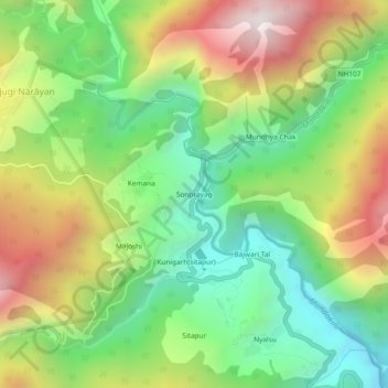
Name: Topografische Karte Sonprayag, Höhe, Relief.
Ort: Sonprayag, Ukhimath, Rudraprayag, Uttarakhand, 246471, India (30.61171 78.97866 30.65171 79.01866)
Durchschnittliche Höhe: 2.053 m
Minimale Höhe: 1.521 m
Maximale Höhe: 2.825 m
Andere topografische Karten
Klicken Sie auf eine Karte, um ihre Topografie, ihre Höhe und ihr Relief anzuzeigen.
Lake Vasuki Tal
India > Uttarakhand > Ukhimath > Kedarnath
Lake Vasuki Tal, Kedarnath, Ukhimath, Rudraprayag District, Uttarakhand, India
Durchschnittliche Höhe: 4.303 m
Chorabari Glacier
India > Uttarakhand > Ukhimath > Kedarnath
Chorabari Glacier, Kedarnath, Ukhimath, Rudraprayag District, Uttarakhand, India
Durchschnittliche Höhe: 5.011 m
Mansuna
India > Uttarakhand > Ukhimath
Mansuna, Ukhimath, Rudraprayag District, Uttarakhand, 246469, India
Durchschnittliche Höhe: 1.653 m
Uthind
India > Uttarakhand > Ukhimath
Uthind, Ukhimath, Rudraprayag District, Uttarakhand, 246419, India
Durchschnittliche Höhe: 1.601 m
Khunnu
India > Uttarakhand > Ukhimath
Khunnu, Ukhimath, Rudraprayag District, Uttarakhand, India
Durchschnittliche Höhe: 1.841 m
Gaurikund
India > Uttarakhand > Ukhimath
Gaurikund, Ukhimath, Rudraprayag, Uttarakhand, India
Durchschnittliche Höhe: 2.589 m
Kedarnath
India > Uttarakhand > Ukhimath
Kedarnath, Ukhimath, Rudraprayag District, Uttarakhand, India
Durchschnittliche Höhe: 4.219 m
Sersi
India > Uttarakhand > Ukhimath > Sersi
Sersi, Ukhimath, Rudraprayag, Uttarakhand, 246471, India
Durchschnittliche Höhe: 1.942 m
Chopta Chatti
India > Uttarakhand > Ukhimath > Chopta Chatti
Chopta Chatti, Ukhimath, Rudraprayag, Uttarakhand, India
Durchschnittliche Höhe: 2.759 m
Guptkashi
India > Uttarakhand > Ukhimath
Guptkashi, Ukhimath, Rudraprayag District, Uttarakhand, 246439, India
Durchschnittliche Höhe: 1.449 m