
Topografische Karte Washington
Interaktive Karte
Klicken Sie auf die Karte, um die Höhe anzuzeigen.
Über diese Karte
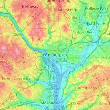
Name: Topografische Karte Washington, Höhe, Relief.
Ort: Washington, District of Columbia, United States (38.79163 -77.11979 38.99597 -76.90937)
Durchschnittliche Höhe: 52 m
Minimale Höhe: -3 m
Maximale Höhe: 138 m
The highest natural elevation in the district is 409 feet (125 m) above sea level at Fort Reno Park in upper northwest Washington. The lowest point is sea level at the Potomac River. The geographic center of Washington is near the intersection of 4th and L Streets NW.
Andere topografische Karten
Klicken Sie auf eine Karte, um ihre Topografie, ihre Höhe und ihr Relief anzuzeigen.
Ward 1
United States > District of Columbia > Washington
Ward 1, Washington, District of Columbia, United States
Durchschnittliche Höhe: 50 m
Ward 3
United States > District of Columbia > Washington
Ward 3, Washington, District of Columbia, United States
Durchschnittliche Höhe: 70 m
Ward 2
United States > District of Columbia > Washington
Ward 2, Washington, District of Columbia, United States
Durchschnittliche Höhe: 23 m
National Mall
United States > District of Columbia > Washington
National Mall, Washington, District of Columbia, United States
Durchschnittliche Höhe: 11 m
Ward 4
United States > District of Columbia > Washington
Ward 4, Washington, District of Columbia, United States
Durchschnittliche Höhe: 78 m
Ward 6
United States > District of Columbia > Washington
Ward 6, Washington, District of Columbia, United States
Durchschnittliche Höhe: 14 m
Ward 5
United States > District of Columbia > Washington
Ward 5, Washington, District of Columbia, United States
Durchschnittliche Höhe: 35 m
The Yards Park
United States > District of Columbia > Washington
The Yards Park, Navy Yard, Washington, District of Columbia, 20003, United States
Durchschnittliche Höhe: 11 m
Point Reno
United States > District of Columbia > Washington
Point Reno, Washington, District of Columbia, 20015, United States
Durchschnittliche Höhe: 98 m
Fort Reno Park
United States > District of Columbia > Washington
Fort Reno Park, American University Park, Washington, District of Columbia, 20016, United States
Durchschnittliche Höhe: 97 m
Mount Vernon Square
United States > District of Columbia > Washington
Mount Vernon Square, Downtown, Washington, District of Columbia, United States
Durchschnittliche Höhe: 24 m
Field #1
United States > District of Columbia > Washington
Field #1, Washington, District of Columbia, United States
Durchschnittliche Höhe: 5 m
Capitol Hill
United States > District of Columbia > Washington
Capitol Hill, Washington, District of Columbia, 20215, United States
Durchschnittliche Höhe: 18 m
Takoma
United States > District of Columbia > Montgomery County > Washington
Takoma, Washington, Montgomery County, District of Columbia, United States
Durchschnittliche Höhe: 87 m
Lafayette Square
United States > District of Columbia > Washington
Lafayette Square, Washington, District of Columbia, United States
Durchschnittliche Höhe: 22 m