
Topografische Karte Hayes County
Interaktive Karte
Klicken Sie auf die Karte, um die Höhe anzuzeigen.
Über diese Karte
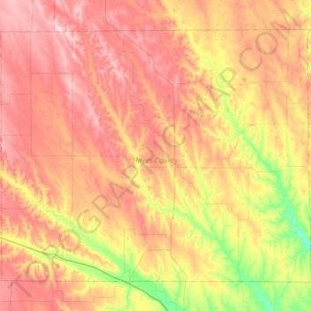
Name: Topografische Karte Hayes County, Höhe, Relief.
Ort: Hayes County, Nebraska, 69032, United States of America (40.34876 -101.34319 40.70016 -100.77559)
Durchschnittliche Höhe: 921 m
Minimale Höhe: 796 m
Maximale Höhe: 1.038 m
The terrain of Hayes County is hilly. The flattened hilltops are largely used for center pivot irrigation. Small creeks and streams drain the upper elevations; the largest is Red Willow Creek, which drains to Hugh Butler Lake just east of the SE corner of Hayes County, in Frontier County. The county has a total area of 713 square miles (1,850 km2), of which 713 square miles (1,850 km2) is land and 0.2 square miles (0.52 km2) (0.03%) is water.
Andere topografische Karten
Klicken Sie auf eine Karte, um ihre Topografie, ihre Höhe und ihr Relief anzuzeigen.
Chadron
United States of America > Nebraska > Chadron
Chadron, Dawes County, Nebraska, 69337, United States of America
Durchschnittliche Höhe: 1.052 m
Red Cloud
United States of America > Nebraska > Red Cloud
Red Cloud, Webster County, Nebraska, United States of America
Durchschnittliche Höhe: 525 m
Osceola
United States of America > Nebraska > Osceola
Osceola, Polk County, Nebraska, 68651, United States of America
Durchschnittliche Höhe: 507 m
Maywood
United States of America > Nebraska > Maywood
Maywood, Frontier County, Nebraska, United States of America
Durchschnittliche Höhe: 829 m
Craig
United States of America > Nebraska > Craig
Craig, Burt County, Nebraska, United States of America
Durchschnittliche Höhe: 398 m
Webster County
United States of America > Nebraska
Webster County, Nebraska, United States of America
Durchschnittliche Höhe: 576 m
Staplehurst
United States of America > Nebraska > Staplehurst
Staplehurst, Seward County, Nebraska, United States of America
Durchschnittliche Höhe: 456 m
Malcolm
United States of America > Nebraska > Malcolm
Malcolm, Lancaster County, Nebraska, United States of America
Durchschnittliche Höhe: 406 m