
Topografische Karte Mamidipally
Interaktive Karte
Klicken Sie auf die Karte, um die Höhe anzuzeigen.
Über diese Karte
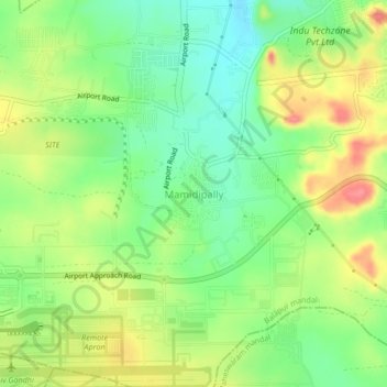
Name: Topografische Karte Mamidipally, Höhe, Relief.
Ort: Mamidipally, Balapur mandal, Rangareddy, Telangana, India (17.22930 78.43144 17.26930 78.47144)
Durchschnittliche Höhe: 606 m
Minimale Höhe: 572 m
Maximale Höhe: 650 m
Andere topografische Karten
Klicken Sie auf eine Karte, um ihre Topografie, ihre Höhe und ihr Relief anzuzeigen.
Kurmalguda
India > Telangana > Balapur mandal
Kurmalguda, Balapur mandal, Ranga Reddy District, Telangana, 500021, India
Durchschnittliche Höhe: 567 m