
Topografische Karte Épernon
Interaktive Karte
Klicken Sie auf die Karte, um die Höhe anzuzeigen.
Über diese Karte
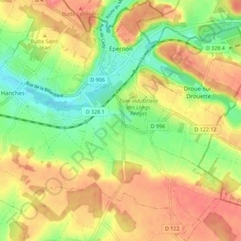
Name: Topografische Karte Épernon, Höhe, Relief.
Durchschnittliche Höhe: 141 m
Minimale Höhe: 107 m
Maximale Höhe: 172 m
Andere topografische Karten
Klicken Sie auf eine Karte, um ihre Topografie, ihre Höhe und ihr Relief anzuzeigen.
Les Épinolières
France > Centre-Val de Loire > Eure-et-Loir > Charbonnières
Les Épinolières, Charbonnières, Nogent-le-Rotrou, Eure-et-Loir, Centre-Val de Loire, Metropolitan France, 28330, France
Durchschnittliche Höhe: 224 m
Dreux
France > Centre-Val de Loire > Eure-et-Loir
Dreux, Eure-et-Loir, Centre-Val de Loire, Metropolitan France, 28100, France
Durchschnittliche Höhe: 113 m
Luray
France > Centre-Val de Loire > Eure-et-Loir
Luray, Dreux, Eure-et-Loir, Centre-Val de Loire, Metropolitan France, 28500, France
Durchschnittliche Höhe: 125 m
Rueil-la-Gadelière
France > Centre-Val de Loire > Eure-et-Loir
Rueil-la-Gadelière, Dreux, Eure-et-Loir, Centre-Val de Loire, Metropolitan France, 28270, France
Durchschnittliche Höhe: 176 m