
Topografische Karte Wyoming
Interaktive Karte
Klicken Sie auf die Karte, um die Höhe anzuzeigen.
Über diese Karte
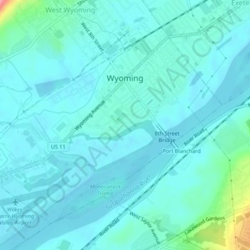
Name: Topografische Karte Wyoming, Höhe, Relief.
Ort: Wyoming, Luzerne County, Pennsylvania, United States (41.29455 -75.86141 41.31773 -75.82214)
Durchschnittliche Höhe: 174 m
Minimale Höhe: 159 m
Maximale Höhe: 270 m
The flood of 2011 prompted the evacuation of the Wilkes-Barre Wyoming Valley Airport (in southern Wyoming). The planes were moved to a higher elevation to prevent flood damage; they were relocated to the Wyoming Monument.