
Topografische Karte Mierzeszyn
Interaktive Karte
Klicken Sie auf die Karte, um die Höhe anzuzeigen.
Über diese Karte
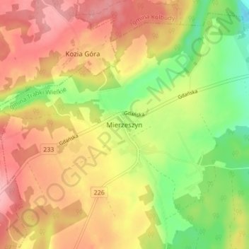
Name: Topografische Karte Mierzeszyn, Höhe, Relief.
Durchschnittliche Höhe: 208 m
Minimale Höhe: 140 m
Maximale Höhe: 265 m
Andere topografische Karten
Klicken Sie auf eine Karte, um ihre Topografie, ihre Höhe und ihr Relief anzuzeigen.
Rokitnica
Poland > Pomeranian Voivodeship > Gdańsk County
Rokitnica, gmina Pruszcz Gdański, Gdańsk County, Pomeranian Voivodeship, Poland
Durchschnittliche Höhe: 1 m
Ostrowite
Poland > Pomeranian Voivodeship > Gdańsk County
Ostrowite, gmina Pszczółki, Gdańsk County, Pomeranian Voivodeship, Poland
Durchschnittliche Höhe: 9 m
Kozia Góra
Poland > Pomeranian Voivodeship > Gdańsk County
Kozia Góra, gmina Przywidz, Gdańsk County, Pomeranian Voivodeship, 83-041, Poland
Durchschnittliche Höhe: 222 m
Przywidz
Poland > Pomeranian Voivodeship > Gdańsk County
Przywidz, gmina Przywidz, Gdańsk County, Pomeranian Voivodeship, 83-047, Poland
Durchschnittliche Höhe: 221 m