Geolokalisieren

Topografische Karte Mandiram

Interaktive Karte

Klicken Sie auf die Karte, um die Höhe anzuzeigen.

Über diese Karte

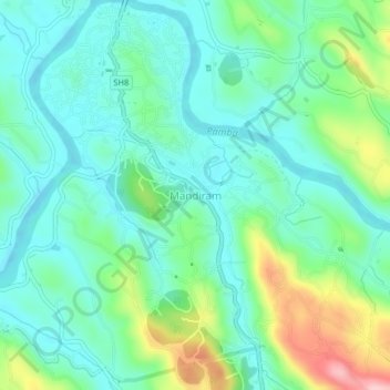
Name: Topografische Karte Mandiram, Höhe, Relief.

Ort: Mandiram, Ranni, Pathanamthitta District, Kerala, 689672, India (9.34008 76.76715 9.38008 76.80715)

Durchschnittliche Höhe: 51 m

Minimale Höhe: -2 m

Maximale Höhe: 195 m

Andere topografische Karten

Klicken Sie auf eine Karte, um ihre Topografie, ihre Höhe und ihr Relief anzuzeigen.

Chethonkara

India > Kerala > Ranni

Chethonkara, Ranni, Pathanamthitta District, Kerala, 689675, India

Durchschnittliche Höhe: 59 m

Ayiroor

India > Kerala > Ranni

Ayiroor, Ranni, Pathanamthitta, Kerala, India

Durchschnittliche Höhe: 53 m

Plappally

India > Kerala > Ranni

Plappally, Ranni, Pathanamthitta, Kerala, India

Durchschnittliche Höhe: 329 m

Perumthenaruvi

India > Kerala > Ranni > Varkkalamukku

Perumthenaruvi, Varkkalamukku, Ranni, Pathanamthitta, Kerala, India

Durchschnittliche Höhe: 158 m

Perunthenaruvi Checkdam

India > Kerala > Ranni > Kurumbanmoozhy

Perunthenaruvi Checkdam, Kurumbanmoozhy, Ranni, Pathanamthitta, Kerala, 686510, India

Durchschnittliche Höhe: 123 m

Mamukku

India > Kerala > Ranni > Mamukku

Mamukku, Ranni, Pathanamthitta, Kerala, 689673, India

Durchschnittliche Höhe: 38 m