
Topografische Karte Shiloh
Interaktive Karte
Klicken Sie auf die Karte, um die Höhe anzuzeigen.
Shiloh
Shiloh is located west of the center of DeKalb County at 34°27′56″N 85°52′38″W / 34.46556°N 85.87722°W / 34.46556; -85.87722 at an elevation of 1,263 feet (385 m). It is bordered to the northeast by the city of Rainsville and to the southwest by the town of Fyffe. Alabama State Route 75 passes through Shiloh, connecting Rainsville and Fyffe.
Über diese Karte
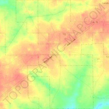
Name: Topografische Karte Shiloh, Höhe, Relief.
Ort: Shiloh, DeKalb County, Alabama, United States (34.45012 -85.89501 34.48078 -85.85989)
Durchschnittliche Höhe: 378 m
Minimale Höhe: 352 m
Maximale Höhe: 394 m