
Spenden
Rüsten Sie sich für Ihr nächstes Abenteuer:
Als Amazon-Partner verdient diese Website an qualifizierten Käufen, ohne dass Ihnen zusätzliche Kosten entstehen.
Topografische Karte Isla de la Corota
Klicken Sie auf die Karte, um die Höhe anzuzeigen.
Spenden
Rüsten Sie sich für Ihr nächstes Abenteuer:
Als Amazon-Partner verdient diese Website an qualifizierten Käufen, ohne dass Ihnen zusätzliche Kosten entstehen.
Über diese Karte
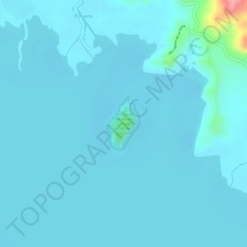
Name: Topografische Karte Isla de la Corota, Höhe, Relief.
Ort: Isla de la Corota, Pasto, Centro, Nariño, Colombia (1.12620 -77.15129 1.13210 -77.14762)
Durchschnittliche Höhe: 2.786 m
Minimale Höhe: 2.776 m
Maximale Höhe: 2.897 m
Spenden
Rüsten Sie sich für Ihr nächstes Abenteuer:
Als Amazon-Partner verdient diese Website an qualifizierten Käufen, ohne dass Ihnen zusätzliche Kosten entstehen.
Andere topografische Karten
Klicken Sie auf eine Karte, um ihre Topografie, ihre Höhe und ihr Relief anzuzeigen.
Spenden
Rüsten Sie sich für Ihr nächstes Abenteuer:
Als Amazon-Partner verdient diese Website an qualifizierten Käufen, ohne dass Ihnen zusätzliche Kosten entstehen.
Perímetro Urbano Pasto
El municipio está situado en el suroccidente de Colombia, en medio de la cordillera de los Andes en el macizo montañoso denominado nudo de los Pastos y la ciudad está situada en el denominado valle de Atriz, al pie del volcán Galeras y está muy cercana a la línea del ecuador y a una altitud de 2527…
Durchschnittliche Höhe: 2.676 m
Spenden
Rüsten Sie sich für Ihr nächstes Abenteuer:
Als Amazon-Partner verdient diese Website an qualifizierten Käufen, ohne dass Ihnen zusätzliche Kosten entstehen.
Spenden
Rüsten Sie sich für Ihr nächstes Abenteuer:
Als Amazon-Partner verdient diese Website an qualifizierten Käufen, ohne dass Ihnen zusätzliche Kosten entstehen.
Spenden
Rüsten Sie sich für Ihr nächstes Abenteuer:
Als Amazon-Partner verdient diese Website an qualifizierten Käufen, ohne dass Ihnen zusätzliche Kosten entstehen.
Perímetro Urbano Pasto
El municipio está situado en el suroccidente de Colombia, en medio de la cordillera de los Andes en el macizo montañoso denominado nudo de los Pastos y la ciudad está situada en el denominado valle de Atriz, al pie del volcán Galeras y está muy cercana a la línea del ecuador y a una altitud de 2527…
Durchschnittliche Höhe: 2.676 m
Spenden
Rüsten Sie sich für Ihr nächstes Abenteuer:
Als Amazon-Partner verdient diese Website an qualifizierten Käufen, ohne dass Ihnen zusätzliche Kosten entstehen.
Perímetro Urbano Pasto
El municipio está situado en el suroccidente de Colombia, en medio de la cordillera de los Andes en el macizo montañoso denominado nudo de los Pastos y la ciudad está situada en el denominado valle de Atriz, al pie del volcán Galeras y está muy cercana a la línea del ecuador y a una altitud de 2527…
Durchschnittliche Höhe: 2.676 m