
Topografische Karte Bagumbayan
Interaktive Karte
Klicken Sie auf die Karte, um die Höhe anzuzeigen.
Über diese Karte
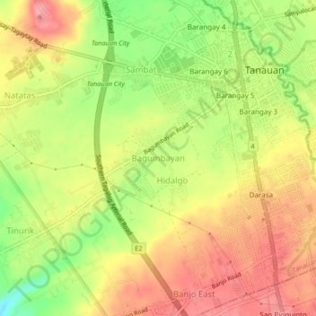
Name: Topografische Karte Bagumbayan, Höhe, Relief.
Ort: Bagumbayan, Tanauan, Batangas, Calabarzon, 4232, Philippines (14.05420 121.11891 14.09420 121.15891)
Durchschnittliche Höhe: 160 m
Minimale Höhe: 103 m
Maximale Höhe: 202 m
Andere topografische Karten
Klicken Sie auf eine Karte, um ihre Topografie, ihre Höhe und ihr Relief anzuzeigen.
2
Philippines > Batangas > Tanauan
2, Tanauan, Batangas, Calabarzon, 4232, Philippines
Durchschnittliche Höhe: 154 m
Santor
Philippines > Batangas > Tanauan
Santor, Tanauan, Batangas, Calabarzon, 4232, Philippines
Durchschnittliche Höhe: 149 m
Hidalgo
Philippines > Batangas > Tanauan
Hidalgo, Tanauan, Batangas, Calabarzon, 4232, Philippines
Durchschnittliche Höhe: 163 m
Balele
Philippines > Batangas > Tanauan
Balele, Tanauan, Batangas, Calabarzon, 4232, Philippines
Durchschnittliche Höhe: 98 m
Pantay Matanda
Philippines > Batangas > Tanauan
Pantay Matanda, Tanauan, Batangas, Calabarzon, 4232, Philippines
Durchschnittliche Höhe: 138 m
Bañadero
Philippines > Batangas > Tanauan
Bañadero, Tanauan, Batangas, Calabarzon, 4232, Philippines
Durchschnittliche Höhe: 53 m
Suplang
Philippines > Batangas > Tanauan > Suplang
Suplang, Tanauan, Batangas, Calabarzon, 4232, Philippines
Durchschnittliche Höhe: 249 m
San Juan River
Philippines > Batangas > Tanauan
San Juan River, Tanauan, Batangas, Calabarzon, 4232, Philippines
Durchschnittliche Höhe: 138 m
Wawa
Philippines > Batangas > Tanauan > Wawa
Wawa, Tanauan, Batangas, Calabarzon, 4232, Philippines
Durchschnittliche Höhe: 62 m
Pagaspas
Philippines > Batangas > Tanauan > Pagaspas
Pagaspas, Tanauan, Batangas, Calabarzon, 4232, Philippines
Durchschnittliche Höhe: 143 m
Trapiche
Philippines > Batangas > Tanauan > Trapiche
Trapiche, Tanauan, Batangas, Calabarzon, 4232, Philippines
Durchschnittliche Höhe: 151 m