
Topografische Karte Macauley Island
Interaktive Karte
Klicken Sie auf die Karte, um die Höhe anzuzeigen.
Über diese Karte
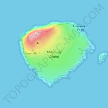
Name: Topografische Karte Macauley Island, Höhe, Relief.
Ort: Macauley Island, Neuseeland (-30.24193 -178.44016 -30.22560 -178.41815)
Durchschnittliche Höhe: 23 m
Minimale Höhe: -8 m
Maximale Höhe: 218 m
Andere topografische Karten
Klicken Sie auf eine Karte, um ihre Topografie, ihre Höhe und ihr Relief anzuzeigen.
Linwood-Central-Heathcote Community
Neuseeland > Canterbury > Christchurch City
Linwood-Central-Heathcote Community, Christchurch City, Canterbury, Neuseeland
Durchschnittliche Höhe: 55 m
Christchurch
Neuseeland > Canterbury > Christchurch
Christchurch, Christchurch City, Canterbury, Neuseeland
Durchschnittliche Höhe: 41 m
Queenstown
Queenstown, Queenstown-Lakes District, Otago, 9348, Neuseeland
Durchschnittliche Höhe: 596 m
Waitemata
Neuseeland > Auckland > Waitemata
Waitemata, Auckland, Neuseeland
Durchschnittliche Höhe: 32 m
Hinuera
Neuseeland > Waikato > Hinuera
Hinuera, Matamata Piako District, Waikato, Neuseeland
Durchschnittliche Höhe: 84 m
Aoraki / Mount Cook
Aoraki / Mount Cook, Mackenzie District, Canterbury, Neuseeland
Durchschnittliche Höhe: 2.920 m
Rangitoto Island
Neuseeland > Auckland > Waiheke
Rangitoto Island, Waiheke, Auckland, Neuseeland
Durchschnittliche Höhe: 30 m
Reefton
Reefton, Buller District, West Coast, 7830, Neuseeland
Durchschnittliche Höhe: 310 m
Lake Ōkataina
Neuseeland > Bay of Plenty > Ruato
Lake Ōkataina, Eastern Okataina Walkway, Ruato, Rotorua District, Bay of Plenty, Neuseeland
Durchschnittliche Höhe: 440 m
Mount Ngāuruhoe
Mount Ngāuruhoe, Ruapehu District, Manawatu-Wanganui, Neuseeland
Durchschnittliche Höhe: 1.726 m
Reporoa
Neuseeland > Waikato > Reporoa
Reporoa, Rotorua District, Waikato, Neuseeland
Durchschnittliche Höhe: 304 m
Whakatāne District
Whakatāne District, Bay of Plenty, Neuseeland
Durchschnittliche Höhe: 416 m
Lake Benmore
Lake Benmore, Falston Road, Waitaki District, Canterbury, Neuseeland
Durchschnittliche Höhe: 746 m
Mayor Island / Tuhua
Neuseeland > Bay of Plenty > Tauranga
Mayor Island / Tuhua, Tauranga, Bay of Plenty, Neuseeland
Durchschnittliche Höhe: 71 m
Ruapehu
Ruapehu, Ruapehu District, Manawatu-Wanganui, Neuseeland
Durchschnittliche Höhe: 2.439 m
Rotorua District
Rotorua District, Bay of Plenty, Neuseeland
Durchschnittliche Höhe: 404 m
Monowai
Monowai, Southland District, Southland, Neuseeland
Durchschnittliche Höhe: 186 m
Nordinsel
Nordinsel, South Waikato District, Waikato, Neuseeland
Durchschnittliche Höhe: 66 m
Wellington City
Wellington City, Wellington, Neuseeland
Durchschnittliche Höhe: 80 m
Lake Karapiro
Neuseeland > Waikato > Arapuni
Lake Karapiro, Waikato River Trail, Arapuni, South Waikato District, Waikato, 3494, Neuseeland
Durchschnittliche Höhe: 174 m
Godley Glacier
Godley Glacier, Mackenzie District, Canterbury, Neuseeland
Durchschnittliche Höhe: 1.579 m
Lake Rotorangi
Lake Rotorangi, Rotorangi Road, South Taranaki District, Taranaki, Neuseeland
Durchschnittliche Höhe: 139 m