
Topografische Karte Pinnacle Peak Park
Interaktive Karte
Klicken Sie auf die Karte, um die Höhe anzuzeigen.
Über diese Karte
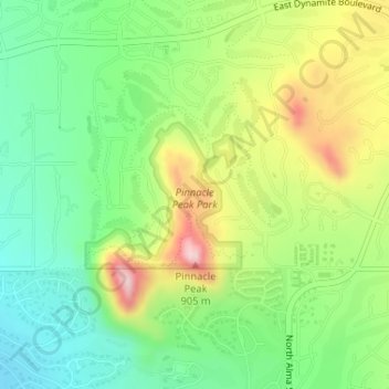
Name: Topografische Karte Pinnacle Peak Park, Höhe, Relief.
Durchschnittliche Höhe: 762 m
Minimale Höhe: 664 m
Maximale Höhe: 915 m
Pinnacle Peak is a granite summit located in Scottsdale, Arizona. The peak rises to an elevation of 3,169 feet (966 m). It is located within the 150-acre (61 ha) Pinnacle Peak Park, operated by the City of Scottsdale Park District. Part of the Sonoran Desert, the park is home to a variety of native desert flora and fauna. Hikers utilize a 1.75 mile trail to explore the area, though rock climbing skills are needed to reach the summit.
Andere topografische Karten
Klicken Sie auf eine Karte, um ihre Topografie, ihre Höhe und ihr Relief anzuzeigen.
Tom's Thumb
United States > Arizona > Maricopa County > Scottsdale
Tom's Thumb, Scottsdale, Maricopa County, Arizona, United States
Durchschnittliche Höhe: 981 m
Butte Peak
United States > Arizona > Maricopa County > Scottsdale
Butte Peak, Scottsdale, Maricopa County, Arizona, United States
Durchschnittliche Höhe: 1.279 m
Pinnacle Peak
United States > Arizona > Maricopa County > Scottsdale
Pinnacle Peak, Scottsdale, Maricopa County, Arizona, United States
Durchschnittliche Höhe: 753 m
Brown's Mountain
United States > Arizona > Maricopa County > Scottsdale
Brown's Mountain, Scottsdale, Maricopa County, Arizona, 85262, United States
Durchschnittliche Höhe: 827 m