
Topografische Karte Palhi
Interaktive Karte
Klicken Sie auf die Karte, um die Höhe anzuzeigen.
Über diese Karte
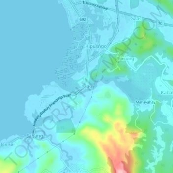
Name: Topografische Karte Palhi, Höhe, Relief.
Durchschnittliche Höhe: 20 m
Minimale Höhe: -2 m
Maximale Höhe: 163 m
Andere topografische Karten
Klicken Sie auf eine Karte, um ihre Topografie, ihre Höhe und ihr Relief anzuzeigen.
Patag
Philippines > Leyte > Baybay
Patag, Baybay, 5th District, Leyte, Eastern Visayas, 6521, Philippines
Durchschnittliche Höhe: 64 m
Baybay
Philippines > Leyte > Baybay
Baybay, Leyte 5th District, Leyte, Eastern Visayas, 6521, Philippines
Durchschnittliche Höhe: 163 m
Lower Utod (Guadalupe)
Philippines > Leyte > Baybay
Lower Utod (Guadalupe), Baybay, Leyte 5th District, Leyte, Eastern Visayas, 6521, Philippines
Durchschnittliche Höhe: 29 m
Pagbanganan River
Philippines > Leyte > Baybay > Kantagnos
Pagbanganan River, Kantagnos, Baybay, Leyte 5th District, Leyte, Eastern Visayas, 6521, Philippines
Durchschnittliche Höhe: 145 m
Mount Pangasugan
Philippines > Leyte > Baybay
Mount Pangasugan, Baybay, Leyte 5th District, Leyte, Eastern Visayas, 6521, Philippines
Durchschnittliche Höhe: 712 m
Mailhi
Philippines > Leyte > Baybay > Mailhi
Mailhi, Baybay, Leyte 5th District, Leyte, Eastern Visayas, 6521, Philippines
Durchschnittliche Höhe: 237 m
Caridad
Philippines > Leyte > Baybay
Caridad, Baybay, 5th District, Leyte, Eastern Visayas, 6521, Philippines
Durchschnittliche Höhe: 33 m
Pangasugan River
Philippines > Leyte > Baybay
Pangasugan River, Baybay, Leyte 5th District, Leyte, Eastern Visayas, 6521, Philippines
Durchschnittliche Höhe: 194 m