Topografische Karte Ottawa
Interaktive Karte
Klicken Sie auf die Karte, um die Höhe anzuzeigen.
Über diese Karte
![Topografische Karte Ottawa, Höhe, Relief](/pub/maps/relation/p2cz/s15n1h/thumbnail.jpg)
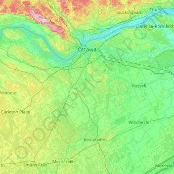
Name: Topografische Karte Ottawa, Höhe, Relief.
Ort: Ottawa, Eastern Ontario, Ontario, Kanada (44.96177 -76.35559 45.53765 -75.24658)
Durchschnittliche Höhe: 105 m
Minimale Höhe: 38 m
Maximale Höhe: 409 m
Während der Wintermonate dominieren Schnee und Eis. Jedes Jahr fällt in der Summe etwa 235 cm Schnee. Die größte je gemessene Schneemenge an einem Tag war 73 cm am 2. März 1947. Die durchschnittliche Temperatur im Januar beträgt −10,8 °C mit starken Schwankungen zwischen den Tag- und Nachttemperaturen. Während die Tagestemperaturen leicht über der Null-Grad-Grenze liegen können, fallen die Nachttemperaturen hin und wieder auf unter −30 °C. In einem durchschnittlichen Winter liegt die Hauptstadt von Mitte Dezember bis Anfang April unter einer geschlossenen Schneedecke, obwohl es auch schneefreie Tage um die Weihnachtszeit geben kann. Der Winter 2007/08 war dabei mit insgesamt 432,7 cm Schnee besonders ergiebig, die Schneehöhe lag damit nur knapp unter der des Rekordjahres 1970/71 von 444,1 cm. Hohe Windchills sind dabei ebenso üblich wie überfrierender Regen. Einer dieser Eisstürme verursachte im Januar 1998 sogar Stromausfälle und beeinträchtigte die lokale Wirtschaft erheblich.
Andere topografische Karten
Klicken Sie auf eine Karte, um ihre Topografie, ihre Höhe und ihr Relief anzuzeigen.
![Topografische Karte Wyoming, Höhe, Relief](/pub/maps/node/vdrr/9g6smv9m/icon.jpg)
Wyoming
Kanada > Ontario > Lambton County
Wyoming, Plympton-Wyoming, Lambton County, Ontario, N0N 1T0, Kanada
Durchschnittliche Höhe: 216 m
![Topografische Karte Silver Lake, Höhe, Relief](/pub/maps/node/n73q/kjvv1wt6/icon.jpg)
Silver Lake
Kanada > Ontario > Kawartha Lakes
Silver Lake, Kawartha Lakes, Central Ontario, Ontario, K0M 1K0, Kanada
Durchschnittliche Höhe: 275 m
![Topografische Karte Grand River, Höhe, Relief](/pub/maps/relation/trcz/xvxtb3/icon.jpg)
Grand River
Grand River, Wellington County, Southwestern Ontario, Ontario, N0B 2V0, Kanada
Durchschnittliche Höhe: 300 m
![Topografische Karte Young Island, Höhe, Relief](/pub/maps/node/j45k/4dp1r9gp/icon.jpg)
Young Island
Kanada > Ontario > The Archipelago
Young Island, The Archipelago, Parry Sound District, Ontario, Kanada
Durchschnittliche Höhe: 197 m
![Topografische Karte Winnipeg River, Höhe, Relief](/pub/maps/way/s1f3/7ljlmm2/icon.jpg)
Winnipeg River
Kanada > Ontario > Unorganized Kenora District
Winnipeg River, Unorganized Kenora District, Kenora District, Ontario, Kanada
Durchschnittliche Höhe: 323 m
![Topografische Karte Cumberland, Höhe, Relief](/pub/maps/relation/hdmt/x3dr18/icon.jpg)
Cumberland
Kanada > Ontario > Ottawa > Cumberland
Cumberland, Ottawa, Eastern Ontario, Ontario, Kanada
Durchschnittliche Höhe: 75 m
![Topografische Karte Flour Mill, Höhe, Relief](/pub/maps/node/f1f3/kwvqb2tf/icon.jpg)
Flour Mill
Kanada > Ontario > Greater Sudbury
Flour Mill, Greater Sudbury, Ontario, P3C 5J7, Kanada
Durchschnittliche Höhe: 276 m
![Topografische Karte Thunder Bay District, Höhe, Relief](/pub/maps/relation/w53l/x15ws8/icon.jpg)
Thunder Bay District
Thunder Bay District, Ontario, Kanada
Durchschnittliche Höhe: 313 m
![Topografische Karte Dufferin Island, Höhe, Relief](/pub/maps/node/xjt6/hfl6tmgt/icon.jpg)
Dufferin Island
Kanada > Ontario > Northeastern Manitoulin and the Islands
Dufferin Island, Northeastern Manitoulin and the Islands, Manitoulin District, Ontario, Kanada
Durchschnittliche Höhe: 203 m
![Topografische Karte Red Rock River, Höhe, Relief](/pub/maps/way/h3tj/8wf3f1h/icon.jpg)
Red Rock River
Kanada > Ontario > Unorganized North Algoma
Red Rock River, Unorganized North Algoma, Algoma District, Ontario, Kanada
Durchschnittliche Höhe: 395 m
![Topografische Karte Nipigonsee, Höhe, Relief](/pub/maps/relation/fn14/7sv5tf/icon.jpg)
Nipigonsee
Kanada > Ontario > Unorganized Thunder Bay District
Nipigonsee, Unorganized Thunder Bay District, Thunder Bay District, Northwestern Ontario, Ontario, Kanada
Durchschnittliche Höhe: 307 m
![Topografische Karte Timiskaming District, Höhe, Relief](/pub/maps/relation/g1kl/hkr73q/icon.jpg)
Timiskaming District
Timiskaming District, Northeastern Ontario, Ontario, Kanada
Durchschnittliche Höhe: 331 m
![Topografische Karte Victoria Island, Höhe, Relief](/pub/maps/node/979m/854pf8z4/icon.jpg)
Victoria Island
Victoria Island, (Old) Ottawa, Ottawa, Ontario, K1R 1C5, Kanada
Durchschnittliche Höhe: 126 m
![Topografische Karte Stormont, Dundas and Glengarry Counties, Höhe, Relief](/pub/maps/relation/p4gt/h36w3q/icon.jpg)
Stormont, Dundas and Glengarry Counties
Stormont, Dundas and Glengarry Counties, Eastern Ontario, Ontario, Kanada
Durchschnittliche Höhe: 86 m
![Topografische Karte Orléans, Höhe, Relief](/pub/maps/relation/lmgt/s5cqdn/icon.jpg)
Orléans
Kanada > Ontario > Ottawa > Cumberland
Orléans, Cumberland, Ottawa, Ontario, Kanada
Durchschnittliche Höhe: 66 m
![Topografische Karte Michaels Island, Höhe, Relief](/pub/maps/way/6hgt/m5lt5tp/icon.jpg)
Michaels Island
Kanada > Ontario > South Frontenac Township
Michaels Island, South Frontenac Township, Frontenac County, Ontario, Kanada
Durchschnittliche Höhe: 169 m