
Spenden
Rüsten Sie sich für Ihr nächstes Abenteuer:
Als Amazon-Partner verdient diese Website an qualifizierten Käufen, ohne dass Ihnen zusätzliche Kosten entstehen.
Topografische Karte Mount Bromo
Klicken Sie auf die Karte, um die Höhe anzuzeigen.
Spenden
Rüsten Sie sich für Ihr nächstes Abenteuer:
Als Amazon-Partner verdient diese Website an qualifizierten Käufen, ohne dass Ihnen zusätzliche Kosten entstehen.
Mount Bromo
Further eruptions and the issuing of aviation ash advisories during the period 27–28 January 2011 led to concerns being raised regarding a volcanic ash plume, reported to be drifting eastward toward the air corridors used to access the Ngurah Rai International Airport IATA:DPS in Bali. Airport official Sherly Yunita was reported at the time as stating that concerns about visibility had prompted Singapore Airlines, Jetstar-ValueAir, Air France-KLM, Virgin Blue and Cathay Pacific to cancel several flights to Bali, 340 km (211 mi) to the east. SilkAir also cancelled flights on the 27 January between Singapore and Lombok, an island to the east of Bali. The Volcanic Ash Advisory Centre in Darwin, Australia released several Code Red Aviation Ash Advisories pertaining to Mount Bromo (Tengger Caldera), on 27 January. They indicated that ash was observed at altitudes up to 18,000 feet (5,486 m) (FL180) extending 200 nautical miles (370 km; 230 mi) to the south east of the caldera. In other ash advisories of that day the cloud was reported as at times having a 10 km/h (6.2 mph) drift, both to the east and to the south east.
Spenden
Rüsten Sie sich für Ihr nächstes Abenteuer:
Als Amazon-Partner verdient diese Website an qualifizierten Käufen, ohne dass Ihnen zusätzliche Kosten entstehen.
Über diese Karte
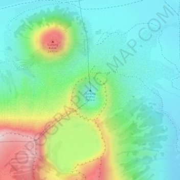
Name: Topografische Karte Mount Bromo, Höhe, Relief.
Ort: Mount Bromo, Pasuruan, East Java, Java, 67254, Indonesia (-7.94212 112.95293 -7.94202 112.95303)
Durchschnittliche Höhe: 2.239 m
Minimale Höhe: 2.110 m
Maximale Höhe: 2.504 m
Spenden
Rüsten Sie sich für Ihr nächstes Abenteuer:
Als Amazon-Partner verdient diese Website an qualifizierten Käufen, ohne dass Ihnen zusätzliche Kosten entstehen.
Andere topografische Karten
Klicken Sie auf eine Karte, um ihre Topografie, ihre Höhe und ihr Relief anzuzeigen.