
Topografische Karte Winburn
Interaktive Karte
Klicken Sie auf die Karte, um die Höhe anzuzeigen.
Über diese Karte
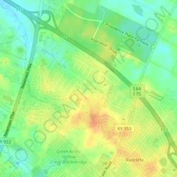
Name: Topografische Karte Winburn, Höhe, Relief.
Ort: Winburn, Lexington, Fayette County, Kentucky, United States (38.08298 -84.48412 38.09555 -84.46667)
Durchschnittliche Höhe: 292 m
Minimale Höhe: 274 m
Maximale Höhe: 311 m
Andere topografische Karten
Klicken Sie auf eine Karte, um ihre Topografie, ihre Höhe und ihr Relief anzuzeigen.
McConnell Springs
United States > Kentucky > Fayette County > Lexington
McConnell Springs, Lexington, Fayette County, Kentucky, United States
Durchschnittliche Höhe: 287 m
Shillito Park
United States > Kentucky > Fayette County > Lexington
Shillito Park, Lexington, Fayette County, Kentucky, United States
Durchschnittliche Höhe: 307 m
Fenwick
United States > Kentucky > Fayette County > Lexington
Fenwick, Lexington, Fayette County, Kentucky, 40516, United States
Durchschnittliche Höhe: 293 m
Paynes
United States > Kentucky > Fayette County > Lexington
Paynes, Lexington, Fayette County, Kentucky, 40504, United States
Durchschnittliche Höhe: 289 m
Jonestown
United States > Kentucky > Fayette County > Lexington > Jonestown
Jonestown, Lexington, Fayette County, Kentucky, 40517, United States
Durchschnittliche Höhe: 297 m
University of Kentucky Arboretum
United States > Kentucky > Fayette County > Lexington
University of Kentucky Arboretum, Glendover, Lexington, Fayette County, Kentucky, United States
Durchschnittliche Höhe: 309 m
Beaumont
United States > Kentucky > Fayette County > Lexington
Beaumont, Lexington, Fayette County, Kentucky, United States
Durchschnittliche Höhe: 299 m