
Topografische Karte New England
Interaktive Karte
Klicken Sie auf die Karte, um die Höhe anzuzeigen.
Über diese Karte
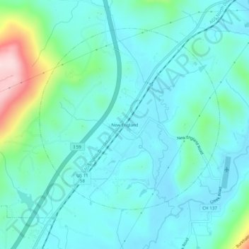
Name: Topografische Karte New England, Höhe, Relief.
Ort: New England, Dade County, Georgia, 30752, United States (34.89036 -85.50024 34.93036 -85.46024)
Durchschnittliche Höhe: 257 m
Minimale Höhe: 199 m
Maximale Höhe: 517 m
Andere topografische Karten
Klicken Sie auf eine Karte, um ihre Topografie, ihre Höhe und ihr Relief anzuzeigen.
Cloudland Canyon State Park
United States > Georgia > Dade County
Cloudland Canyon State Park, Cherokee Trail, Dade County, Georgia, 30738, United States
Durchschnittliche Höhe: 488 m
Trenton
United States > Georgia > Dade County
Trenton, Dade County, Georgia, United States
Durchschnittliche Höhe: 280 m
West Brow
United States > Georgia > Dade County
West Brow, Dade County, Georgia, 30757, United States
Durchschnittliche Höhe: 426 m
Head River
United States > Georgia > Dade County
Head River, Dade County, Georgia, United States
Durchschnittliche Höhe: 585 m
Cole City
United States > Georgia > Dade County
Cole City, Dade County, Georgia, United States
Durchschnittliche Höhe: 431 m
Rising Fawn
United States > Georgia > Dade County
Rising Fawn, Dade County, Georgia, United States
Durchschnittliche Höhe: 314 m
Wildwood
United States > Georgia > Dade County
Wildwood, Dade County, Georgia, 30757, United States
Durchschnittliche Höhe: 258 m
New England
United States > Georgia > Dade County
New England, Dade County, Georgia, United States
Durchschnittliche Höhe: 242 m
Trenton
United States > Georgia > Dade County
Trenton, Dade County, Georgia, United States
Durchschnittliche Höhe: 280 m
Cole City
United States > Georgia > Dade County
Cole City, Dade County, Georgia, United States
Durchschnittliche Höhe: 417 m