
Topografische Karte Saint Joe
Interaktive Karte
Klicken Sie auf die Karte, um die Höhe anzuzeigen.
Über diese Karte
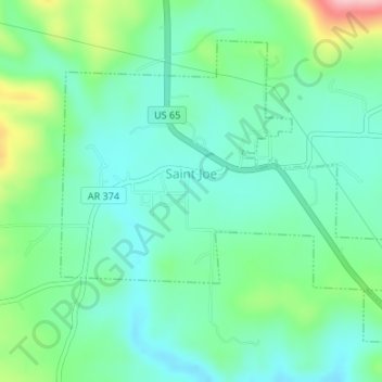
Name: Topografische Karte Saint Joe, Höhe, Relief.
Ort: Saint Joe, Searcy County, Arkansas, 72675, United States (36.01782 -92.82001 36.03916 -92.78902)
Durchschnittliche Höhe: 260 m
Minimale Höhe: 217 m
Maximale Höhe: 377 m
Andere topografische Karten
Klicken Sie auf eine Karte, um ihre Topografie, ihre Höhe und ihr Relief anzuzeigen.
Lead Hill
United States > Arkansas > Searcy County
Lead Hill, Searcy County, Arkansas, United States
Durchschnittliche Höhe: 286 m
Gilbert
United States > Arkansas > Searcy County
Gilbert, Searcy County, Arkansas, 72636, United States
Durchschnittliche Höhe: 216 m
Buffalo River
United States > Arkansas > Searcy County > Gilbert
Buffalo River, Gilbert, Searcy County, Arkansas, 72636, United States
Durchschnittliche Höhe: 217 m
Buffalo National River
United States > Arkansas > Searcy County
Buffalo National River, Searcy County, Arkansas, 72624, United States
Durchschnittliche Höhe: 444 m
Leslie
United States > Arkansas > Searcy County > Leslie > Leslie
Leslie, Searcy County, Arkansas, 72645, United States
Durchschnittliche Höhe: 347 m
Cozahome
United States > Arkansas > Searcy County > Cozahome
Cozahome, Searcy County, Arkansas, United States
Durchschnittliche Höhe: 307 m
Marshall
United States > Arkansas > Searcy County
Marshall, Searcy County, Arkansas, 72650, United States
Durchschnittliche Höhe: 331 m