
Topografische Karte Allen Jay
Interaktive Karte
Klicken Sie auf die Karte, um die Höhe anzuzeigen.
Über diese Karte
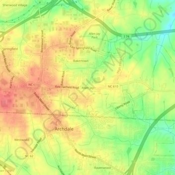
Name: Topografische Karte Allen Jay, Höhe, Relief.
Durchschnittliche Höhe: 254 m
Minimale Höhe: 216 m
Maximale Höhe: 281 m
Andere topografische Karten
Klicken Sie auf eine Karte, um ihre Topografie, ihre Höhe und ihr Relief anzuzeigen.
Oak Hollow Lake
United States > North Carolina > Guilford County > High Point
Oak Hollow Lake, High Point, Guilford County, North Carolina, 27265, United States
Durchschnittliche Höhe: 261 m
City Lake
United States > North Carolina > Guilford County > High Point
City Lake, High Point, Guilford County, North Carolina, United States
Durchschnittliche Höhe: 247 m
Oakview
United States > North Carolina > Guilford County > High Point
Oakview, High Point, Guilford County, North Carolina, 27265, United States
Durchschnittliche Höhe: 264 m
Owens Lake
United States > North Carolina > Guilford County > High Point
Owens Lake, High Point, Guilford County, North Carolina, United States
Durchschnittliche Höhe: 255 m