
Spenden
Rüsten Sie sich für Ihr nächstes Abenteuer:
Als Amazon-Partner verdient diese Website an qualifizierten Käufen, ohne dass Ihnen zusätzliche Kosten entstehen.
Topografische Karte Croteau Lake
Klicken Sie auf die Karte, um die Höhe anzuzeigen.
Spenden
Rüsten Sie sich für Ihr nächstes Abenteuer:
Als Amazon-Partner verdient diese Website an qualifizierten Käufen, ohne dass Ihnen zusätzliche Kosten entstehen.
Über diese Karte
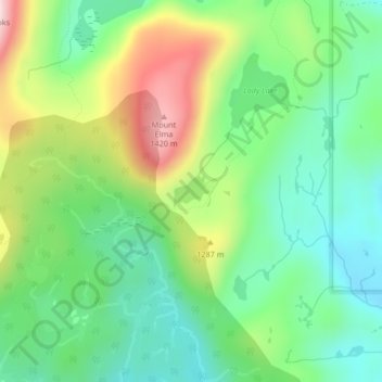
Name: Topografische Karte Croteau Lake, Höhe, Relief.
Durchschnittliche Höhe: 1.195 m
Minimale Höhe: 1.064 m
Maximale Höhe: 1.438 m
Spenden
Rüsten Sie sich für Ihr nächstes Abenteuer:
Als Amazon-Partner verdient diese Website an qualifizierten Käufen, ohne dass Ihnen zusätzliche Kosten entstehen.
Andere topografische Karten
Klicken Sie auf eine Karte, um ihre Topografie, ihre Höhe und ihr Relief anzuzeigen.
Dove Creek
Canada > British Columbia > Comox Valley Regional District > Area C (Puntledge/Black Creek)
Durchschnittliche Höhe: 42 m
Forbidden Plateau
Canada > British Columbia > Comox Valley Regional District > Area C (Puntledge/Black Creek)
Durchschnittliche Höhe: 1.041 m
Mount Washington
Canada > British Columbia > Comox Valley Regional District > Area C (Puntledge/Black Creek)
Durchschnittliche Höhe: 1.279 m
Black Creek
Canada > British Columbia > Comox Valley Regional District > Area C (Puntledge/Black Creek)
Durchschnittliche Höhe: 60 m
Spenden
Rüsten Sie sich für Ihr nächstes Abenteuer:
Als Amazon-Partner verdient diese Website an qualifizierten Käufen, ohne dass Ihnen zusätzliche Kosten entstehen.
Nymph Falls
Canada > British Columbia > Comox Valley Regional District > Area C (Puntledge/Black Creek)
Durchschnittliche Höhe: 128 m
Mount Albert Edward
Canada > British Columbia > Comox Valley Regional District > Area C (Puntledge/Black Creek)
Durchschnittliche Höhe: 1.508 m
Mount Becher
Canada > British Columbia > Comox Valley Regional District > Area C (Puntledge/Black Creek)
Durchschnittliche Höhe: 1.035 m
MacAulay Heights
Canada > British Columbia > Comox Valley Regional District > Area C (Puntledge/Black Creek)
Durchschnittliche Höhe: 94 m
Spenden
Rüsten Sie sich für Ihr nächstes Abenteuer:
Als Amazon-Partner verdient diese Website an qualifizierten Käufen, ohne dass Ihnen zusätzliche Kosten entstehen.
Miracle Beach
Canada > British Columbia > Comox Valley Regional District > Area C (Puntledge/Black Creek) > Miracle Beach
Durchschnittliche Höhe: 30 m
Forbidden Plateau
Canada > British Columbia > Comox Valley Regional District > Area C (Puntledge/Black Creek)
Durchschnittliche Höhe: 650 m