Topografische Karte Bhutti
Interaktive Karte
Klicken Sie auf die Karte, um die Höhe anzuzeigen.
Über diese Karte
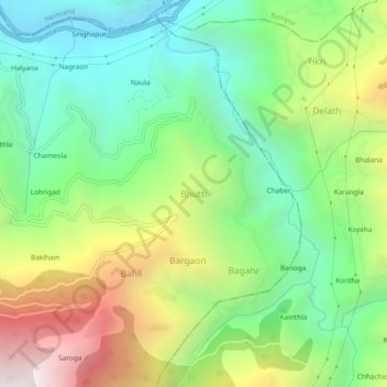
Name: Topografische Karte Bhutti, Höhe, Relief.
Ort: Bhutti, Kumharsain, Shimla, Himachal Pradesh, 172030, India (31.31132 77.50641 31.35132 77.54641)
Durchschnittliche Höhe: 1.431 m
Minimale Höhe: 806 m
Maximale Höhe: 2.504 m
Andere topografische Karten
Klicken Sie auf eine Karte, um ihre Topografie, ihre Höhe und ihr Relief anzuzeigen.
Narkanda
India > Himachal Pradesh > Kumharsain
Narkanda, Kumharsain, Shimla, Himachal Pradesh, 171213, India
Durchschnittliche Höhe: 2.466 m
Kotgarh
India > Himachal Pradesh > Kumharsain > Kotgarh
Kotgarh, Kumharsain, Shimla, Himachal Pradesh, 172031, India
Durchschnittliche Höhe: 1.872 m
Nag Tibba
India > Himachal Pradesh > Kumharsain > Garajubar
Nag Tibba, Garajubar, Kumharsain, Shimla, Himachal Pradesh, 172027, India
Durchschnittliche Höhe: 1.889 m