
Topografische Karte New Washoe City
Interaktive Karte
Klicken Sie auf die Karte, um die Höhe anzuzeigen.
Über diese Karte
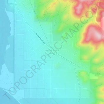
Name: Topografische Karte New Washoe City, Höhe, Relief.
Durchschnittliche Höhe: 1.589 m
Minimale Höhe: 1.529 m
Maximale Höhe: 1.793 m
Andere topografische Karten
Klicken Sie auf eine Karte, um ihre Topografie, ihre Höhe und ihr Relief anzuzeigen.
Cold Springs
United States > Nevada > Washoe County
Cold Springs, Washoe County, Nevada, 89508, United States
Durchschnittliche Höhe: 1.573 m
Nixon
United States > Nevada > Washoe County
Nixon, Washoe County, Nevada, 89424, United States
Durchschnittliche Höhe: 1.209 m
Incline Village-Crystal Bay
United States > Nevada > Washoe County
Incline Village-Crystal Bay, Washoe County, Nevada, United States
Durchschnittliche Höhe: 2.173 m
Reno
United States > Nevada > Washoe County
Reno, Washoe County, Nevada, United States
Durchschnittliche Höhe: 1.650 m
Sparks
United States > Nevada > Washoe County
Sparks, Washoe County, Nevada, United States
Durchschnittliche Höhe: 1.438 m
Oxbow Nature Study Area
United States > Nevada > Washoe County > Reno > West Reno
Oxbow Nature Study Area, West Reno, Reno, Washoe County, Nevada, United States
Durchschnittliche Höhe: 1.415 m
North Valley
United States > Nevada > Washoe County > Reno
North Valley, Reno, Washoe County, Nevada, 89512, United States
Durchschnittliche Höhe: 1.419 m
Pyramid Lake
United States > Nevada > Washoe County
Pyramid Lake, Washoe County, Nevada, United States
Durchschnittliche Höhe: 1.406 m