
Spenden
Rüsten Sie sich für Ihr nächstes Abenteuer:
Als Amazon-Partner verdient diese Website an qualifizierten Käufen, ohne dass Ihnen zusätzliche Kosten entstehen.
Topografische Karte Cave Creek
Klicken Sie auf die Karte, um die Höhe anzuzeigen.
Spenden
Rüsten Sie sich für Ihr nächstes Abenteuer:
Als Amazon-Partner verdient diese Website an qualifizierten Käufen, ohne dass Ihnen zusätzliche Kosten entstehen.
Cave Creek
Cave Creek is a town in the Sonoran Desert. It sits in northern Maricopa County on the northern edge of Paradise Valley, with mountains rising to the north that eventually connect with the New River Mountains and the Black Hills. It is 33 miles (53 km) north of downtown Phoenix, although the Phoenix city limits extend north to Cave Creek's southern border. The town is bordered to the east by the town of Carefree, to the west by unincorporated New River, and to the north by Tonto National Forest. Elephant Mountain rises to an elevation of 3,926 feet (1,197 m) in the northernmost part of the town. Local landmark Black Mountain, elevation 3,398 feet (1,036 m), is in the southern part of town on the border with Carefree.
Spenden
Rüsten Sie sich für Ihr nächstes Abenteuer:
Als Amazon-Partner verdient diese Website an qualifizierten Käufen, ohne dass Ihnen zusätzliche Kosten entstehen.
Über diese Karte
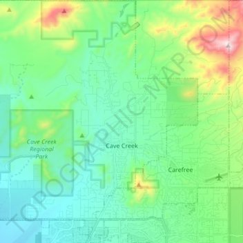
Name: Topografische Karte Cave Creek, Höhe, Relief.
Ort: Cave Creek, Maricopa County, Arizona, United States (33.78831 -112.03051 33.90062 -111.90861)
Durchschnittliche Höhe: 743 m
Minimale Höhe: 555 m
Maximale Höhe: 1.363 m
Spenden
Rüsten Sie sich für Ihr nächstes Abenteuer:
Als Amazon-Partner verdient diese Website an qualifizierten Käufen, ohne dass Ihnen zusätzliche Kosten entstehen.
Andere topografische Karten
Klicken Sie auf eine Karte, um ihre Topografie, ihre Höhe und ihr Relief anzuzeigen.
Scottsdale
United States > Arizona > Maricopa County > Scottsdale
The city is in the Salt River Valley, or the "Valley of the Sun," in the northern reaches of the Sonoran Desert. Scottsdale, 31 mi (50 km) long and 11.4 mi (18.3 km) wide at its widest point, shares boundaries with many other municipalities and entities. On the west, Scottsdale is bordered by Phoenix, Paradise…
Durchschnittliche Höhe: 414 m
Anthem
United States > Arizona > Maricopa County
Anthem is built on 5,856 acres (9.2 sq mi) at the base of Daisy Mountain and Gavilan Peak in northern Maricopa County. The CDP portion of Anthem has an area of 7.9 square miles (20 km2). The community's elevation ranges from 1,760 to 2,428 feet (536 to 740 m), with an average elevation of 1,863 feet (568 m).…
Durchschnittliche Höhe: 578 m
Spenden
Rüsten Sie sich für Ihr nächstes Abenteuer:
Als Amazon-Partner verdient diese Website an qualifizierten Käufen, ohne dass Ihnen zusätzliche Kosten entstehen.
Camelback Mountain
United States > Arizona > Maricopa County > Phoenix
Efforts to protect Camelback Mountain as a natural preserve began in the early 1910s. However, by the 1960s, nearly all of the area had been sold to private interests. Federal and state authorities attempted to stop development above the one thousand and six hundred feet level. They failed to halt development…
Durchschnittliche Höhe: 463 m
Spenden
Rüsten Sie sich für Ihr nächstes Abenteuer:
Als Amazon-Partner verdient diese Website an qualifizierten Käufen, ohne dass Ihnen zusätzliche Kosten entstehen.
Komatke
United States > Arizona > Maricopa County > Komatke
Saint John the Baptist Parish Laveen, the Saint Johns Mission, is in Komatke. The name is taken from the mission school founded by the Franciscans in 1894. It has an estimated elevation of 1,030 feet (310 m) above sea level.
Durchschnittliche Höhe: 335 m
Gilbert Regional Park
United States > Arizona > Maricopa County > Gilbert
Durchschnittliche Höhe: 401 m
Spenden
Rüsten Sie sich für Ihr nächstes Abenteuer:
Als Amazon-Partner verdient diese Website an qualifizierten Käufen, ohne dass Ihnen zusätzliche Kosten entstehen.
Indian School Park
United States > Arizona > Maricopa County > Scottsdale
Durchschnittliche Höhe: 384 m
Phoenix
United States > Arizona > Maricopa County > Phoenix
Phoenix is in the south-central portion of Arizona; about halfway between Tucson to the southeast and Flagstaff to the north, in the southwestern United States. By car, the city is approximately 150 miles (240 kilometers) north of the US–Mexico border at Sonoyta and 180 mi (290 km) north of the border at…
Durchschnittliche Höhe: 368 m
Spenden
Rüsten Sie sich für Ihr nächstes Abenteuer:
Als Amazon-Partner verdient diese Website an qualifizierten Käufen, ohne dass Ihnen zusätzliche Kosten entstehen.
Tempe
United States > Arizona > Maricopa County > Tempe
Tempe is generally flat, except for Hayden Butte (generally known as A-Mountain for Arizona State University's "A" logo located on its south face), located next to Sun Devil Stadium, Twin Buttes and Bell Butte on the western edge of Tempe, and Papago Park northwest of Tempe, inside Phoenix. Elevation ranges…
Durchschnittliche Höhe: 386 m
Spenden
Rüsten Sie sich für Ihr nächstes Abenteuer:
Als Amazon-Partner verdient diese Website an qualifizierten Käufen, ohne dass Ihnen zusätzliche Kosten entstehen.
Spenden
Rüsten Sie sich für Ihr nächstes Abenteuer:
Als Amazon-Partner verdient diese Website an qualifizierten Käufen, ohne dass Ihnen zusätzliche Kosten entstehen.
Spenden
Rüsten Sie sich für Ihr nächstes Abenteuer:
Als Amazon-Partner verdient diese Website an qualifizierten Käufen, ohne dass Ihnen zusätzliche Kosten entstehen.
Sentinel
United States > Arizona > Maricopa County
Sentinel is an unincorporated community in Maricopa County, Arizona, United States. It has an estimated elevation of 692 feet (211 m) above sea level.
Durchschnittliche Höhe: 213 m
Spenden
Rüsten Sie sich für Ihr nächstes Abenteuer:
Als Amazon-Partner verdient diese Website an qualifizierten Käufen, ohne dass Ihnen zusätzliche Kosten entstehen.
Gateway Trailhead
United States > Arizona > Maricopa County > Scottsdale
Durchschnittliche Höhe: 530 m
Spenden
Rüsten Sie sich für Ihr nächstes Abenteuer:
Als Amazon-Partner verdient diese Website an qualifizierten Käufen, ohne dass Ihnen zusätzliche Kosten entstehen.
Camelback Mountain
United States > Arizona > Maricopa County > Phoenix
Efforts to protect Camelback Mountain as a natural preserve began in the early 1910s. However, by the 1960s, nearly all of the area had been sold to private interests. Federal and state authorities attempted to stop development above the one thousand and six hundred feet level. They failed to halt development…
Durchschnittliche Höhe: 462 m
Spenden
Rüsten Sie sich für Ihr nächstes Abenteuer:
Als Amazon-Partner verdient diese Website an qualifizierten Käufen, ohne dass Ihnen zusätzliche Kosten entstehen.
Spenden
Rüsten Sie sich für Ihr nächstes Abenteuer:
Als Amazon-Partner verdient diese Website an qualifizierten Käufen, ohne dass Ihnen zusätzliche Kosten entstehen.
Saddle
United States > Arizona > Maricopa County
Saddle is a populated place situated in Maricopa County, Arizona, United States. It has an estimated elevation of 722 feet (220 m) above sea level. It is located on the Union Pacific Railroad's Phoenix Subdivision.
Durchschnittliche Höhe: 220 m