
Topografische Karte Oso Grande
Interaktive Karte
Klicken Sie auf die Karte, um die Höhe anzuzeigen.
Über diese Karte
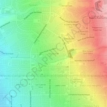
Name: Topografische Karte Oso Grande, Höhe, Relief.
Durchschnittliche Höhe: 1.736 m
Minimale Höhe: 1.659 m
Maximale Höhe: 1.835 m
Andere topografische Karten
Klicken Sie auf eine Karte, um ihre Topografie, ihre Höhe und ihr Relief anzuzeigen.
Sandia Heights
United States > New Mexico > Bernalillo County > Albuquerque
Sandia Heights, Albuquerque, Bernalillo County, New Mexico, 87111, United States
Durchschnittliche Höhe: 1.898 m
Tramway Highpoint (HOA)
United States > New Mexico > Bernalillo County > Albuquerque
Tramway Highpoint (HOA), Albuquerque, Bernalillo County, New Mexico, 87111, United States
Durchschnittliche Höhe: 1.822 m
Albuquerque
United States > New Mexico > Bernalillo County > Albuquerque
Albuquerque, Bernalillo County, New Mexico, 87102, United States
Durchschnittliche Höhe: 1.671 m
Glenwood Hills
United States > New Mexico > Bernalillo County > Albuquerque
Glenwood Hills, Albuquerque, Bernalillo County, New Mexico, 87111, United States
Durchschnittliche Höhe: 1.937 m
Joe M. Lucero Hillside
United States > New Mexico > Bernalillo County > Albuquerque
Joe M. Lucero Hillside, Albuquerque, Bernalillo County, New Mexico, United States
Durchschnittliche Höhe: 1.637 m