
Topografische Karte Lawtons
Interaktive Karte
Klicken Sie auf die Karte, um die Höhe anzuzeigen.
Über diese Karte
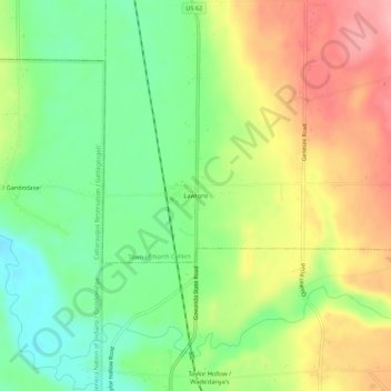
Name: Topografische Karte Lawtons, Höhe, Relief.
Durchschnittliche Höhe: 270 m
Minimale Höhe: 210 m
Maximale Höhe: 344 m
Andere topografische Karten
Klicken Sie auf eine Karte, um ihre Topografie, ihre Höhe und ihr Relief anzuzeigen.
Langford
United States > New York > Erie County > Town of North Collins
Langford, Town of North Collins, Erie County, New York, United States
Durchschnittliche Höhe: 389 m
New Oregon
United States > New York > Erie County > Town of North Collins
New Oregon, Town of North Collins, Erie County, New York, United States
Durchschnittliche Höhe: 390 m
Marshfield
United States > New York > Erie County > Town of North Collins
Marshfield, Town of North Collins, Erie County, New York, United States
Durchschnittliche Höhe: 398 m
Shirley
United States > New York > Erie County > Town of North Collins
Shirley, Town of North Collins, Erie County, New York, 14111, United States
Durchschnittliche Höhe: 322 m