
Topografische Karte Newry
Interaktive Karte
Klicken Sie auf die Karte, um die Höhe anzuzeigen.
Über diese Karte
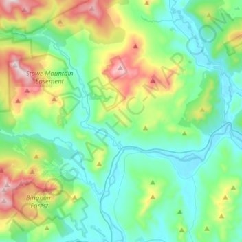
Name: Topografische Karte Newry, Höhe, Relief.
Ort: Newry, Oxford County, Maine, 04261, United States (44.41796 -70.90423 44.59692 -70.70428)
Durchschnittliche Höhe: 392 m
Minimale Höhe: 183 m
Maximale Höhe: 1.019 m
At 20:15 on June 27, 1960, a United States Air Force tanker of the 380th Air Refueling Squadron departed Plattsburgh AFB to refuel a Strategic Air Command bomber. The Boeing KC-97 Stratofreighter rendezvoused with the B-47 Stratojet bomber at an altitude of 15,500 feet in the Fighting Fox aerial refueling area over Newry. As the bomber maneuvered into refueling position, a lubrication failure caused the tanker's outboard port engine supercharger impeller to disintegrate. Impeller fragments leaving the engine nacelle caused fuel leakage. The bomber observed ignition of the leaking fuel and broke away from formation. The tanker entered a gradual left turn, which became a spiraling spin as the fire rapidly caused structural damage to the port wing. Seven miles away, three hundred people at a Rumford Point drive-in theater observed the tanker spin down, with burning pieces flying off. The fuselage impacted a forested slope of granite boulders and caused a fireball seen fifty miles away in Lewiston. The port wing tip was found in Howard Pond, three miles from the crash site. There were no survivors from the tanker's five-man crew. Wet vegetation limited spread of the fire, but fuel-covered trees were completely consumed and the five-acre hillside wreckage field was discernible for years amid the surrounding forest.
Andere topografische Karten
Klicken Sie auf eine Karte, um ihre Topografie, ihre Höhe und ihr Relief anzuzeigen.
Boston Hills
United States > Maine > Oxford County > Denmark
Boston Hills, Denmark, Oxford County, Maine, 04022, United States
Durchschnittliche Höhe: 136 m
Grafton Township
United States > Maine > Oxford County
Grafton Township, Oxford County, Maine, 04261, United States
Durchschnittliche Höhe: 632 m
Mooselookmeguntic Lake
United States > Maine > Oxford County > Adamstown Township
Mooselookmeguntic Lake, Adamstown Township, Oxford County, Maine, United States
Durchschnittliche Höhe: 508 m
Roxbury
United States > Maine > Oxford County
Roxbury, Oxford County, Maine, 04275, United States
Durchschnittliche Höhe: 379 m
West Paris
United States > Maine > Oxford County
West Paris, Oxford County, Maine, 04289, United States
Durchschnittliche Höhe: 234 m
Andover
United States > Maine > Oxford County
Andover, Oxford County, Maine, 04216, United States
Durchschnittliche Höhe: 381 m
Aziscohos Lake
United States > Maine > Oxford County
Aziscohos Lake, Oxford County, Maine, United States
Durchschnittliche Höhe: 589 m
Old Speck Mountain
United States > Maine > Oxford County
Old Speck Mountain, Oxford County, Maine, United States
Durchschnittliche Höhe: 943 m
Rumford
United States > Maine > Oxford County
Rumford, Oxford County, Maine, 04276, United States
Durchschnittliche Höhe: 280 m
Record Hill
United States > Maine > Oxford County > Byron
Record Hill, Byron, Oxford County, Maine, 04275, United States
Durchschnittliche Höhe: 477 m
Otisfield
United States > Maine > Oxford County
Otisfield, Oxford County, Maine, 04270, United States
Durchschnittliche Höhe: 142 m
West Bethel
United States > Maine > Oxford County > Bethel
West Bethel, Bethel, Oxford County, Maine, 04217, United States
Durchschnittliche Höhe: 252 m
Norway
United States > Maine > Oxford County > Norway
Norway, Oxford County, Maine, 04268, United States
Durchschnittliche Höhe: 180 m
Grover Hill
United States > Maine > Oxford County
Grover Hill, Oxford County, Maine, 04217, United States
Durchschnittliche Höhe: 249 m
Sunday River
United States > Maine > Oxford County > Bethel
Sunday River, Bethel, Oxford County, Maine, 04217, United States
Durchschnittliche Höhe: 279 m
Sumner
United States > Maine > Oxford County
Sumner, Oxford County, Maine, 04292, United States
Durchschnittliche Höhe: 223 m
Hartford
United States > Maine > Oxford County
Hartford, Oxford County, Maine, 04220, United States
Durchschnittliche Höhe: 192 m
Greenwood
United States > Maine > Oxford County
Greenwood, Oxford County, Maine, 04255, United States
Durchschnittliche Höhe: 295 m
Byron
United States > Maine > Oxford County
Byron, Oxford County, Maine, 04275, United States
Durchschnittliche Höhe: 492 m
Paris
United States > Maine > Oxford County
Paris, Oxford County, Maine, 04281, United States
Durchschnittliche Höhe: 207 m
Stow
United States > Maine > Oxford County
Stow, Oxford County, Maine, 04037, United States
Durchschnittliche Höhe: 308 m
Lovell
United States > Maine > Oxford County
Lovell, Oxford County, Maine, 04051, United States
Durchschnittliche Höhe: 187 m
Upton
United States > Maine > Oxford County
Upton, Oxford County, Maine, 04261, United States
Durchschnittliche Höhe: 448 m
Dixfield
United States > Maine > Oxford County
Dixfield, Oxford County, Maine, 04224, United States
Durchschnittliche Höhe: 233 m
South Paris
United States > Maine > Oxford County > Paris
South Paris, Paris, Oxford County, Maine, 04281, United States
Durchschnittliche Höhe: 155 m
Oxford
United States > Maine > Oxford County
Oxford, Oxford County, Maine, 04270, United States
Durchschnittliche Höhe: 144 m
Buckfield
United States > Maine > Oxford County
Buckfield, Oxford County, Maine, 04220, United States
Durchschnittliche Höhe: 187 m
Peru
United States > Maine > Oxford County
Peru, Oxford County, Maine, 04290, United States
Durchschnittliche Höhe: 238 m
Porter
United States > Maine > Oxford County
Porter, Oxford County, Maine, 04068, United States
Durchschnittliche Höhe: 197 m
Hiram
United States > Maine > Oxford County
Hiram, Oxford County, Maine, 04041, United States
Durchschnittliche Höhe: 178 m
Bethel
United States > Maine > Oxford County
Bethel, Oxford County, Maine, 04217, United States
Durchschnittliche Höhe: 310 m
Mexico
United States > Maine > Oxford County > Mexico
Mexico, Oxford County, Maine, 04257, United States
Durchschnittliche Höhe: 270 m
Sugarloaf
United States > Maine > Oxford County > Dixfield
Sugarloaf, Dixfield, Oxford County, Maine, 04224, United States
Durchschnittliche Höhe: 237 m
Woodstock
United States > Maine > Oxford County > Woodstock
Woodstock, Oxford County, Maine, 04219, United States
Durchschnittliche Höhe: 316 m
Gilead
United States > Maine > Oxford County
Gilead, Oxford County, Maine, 04217, United States
Durchschnittliche Höhe: 430 m
Fryeburg
United States > Maine > Oxford County
Fryeburg, Oxford County, Maine, 04037, United States
Durchschnittliche Höhe: 200 m
Denmark
United States > Maine > Oxford County
Denmark, Oxford County, Maine, 04022, United States
Durchschnittliche Höhe: 174 m
Sweden
United States > Maine > Oxford County
Sweden, Oxford County, Maine, 04040, United States
Durchschnittliche Höhe: 185 m
Brownfield
United States > Maine > Oxford County > Brownfield
Brownfield, Oxford County, Maine, 04010, United States
Durchschnittliche Höhe: 170 m
Canton
United States > Maine > Oxford County
Canton, Oxford County, Maine, 04221, United States
Durchschnittliche Höhe: 203 m