
Topografische Karte Dover
Interaktive Karte
Klicken Sie auf die Karte, um die Höhe anzuzeigen.
Über diese Karte
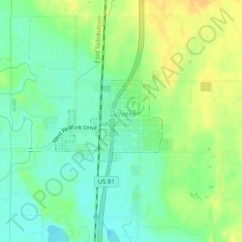
Name: Topografische Karte Dover, Höhe, Relief.
Ort: Dover, Kingfisher County, Oklahoma, 73734, United States (35.97719 -97.91959 35.98634 -97.90482)
Durchschnittliche Höhe: 322 m
Minimale Höhe: 309 m
Maximale Höhe: 336 m
Andere topografische Karten
Klicken Sie auf eine Karte, um ihre Topografie, ihre Höhe und ihr Relief anzuzeigen.
Kingfisher
United States > Oklahoma > Kingfisher County
Kingfisher, Kingfisher County, Oklahoma, 73750, United States
Durchschnittliche Höhe: 329 m
Omega
United States > Oklahoma > Kingfisher County
Omega, Kingfisher County, Oklahoma, 73764, United States
Durchschnittliche Höhe: 367 m
Okarche
United States > Oklahoma > Kingfisher County
Okarche, Kingfisher County, Oklahoma, United States
Durchschnittliche Höhe: 374 m
Cashion
United States > Oklahoma > Kingfisher County
Cashion, Kingfisher County, Oklahoma, 73016, United States
Durchschnittliche Höhe: 339 m
Loyal
United States > Oklahoma > Kingfisher County
Loyal, Kingfisher County, Oklahoma, United States
Durchschnittliche Höhe: 344 m