
Topografische Karte Ermida
Interaktive Karte
Klicken Sie auf die Karte, um die Höhe anzuzeigen.
Über diese Karte
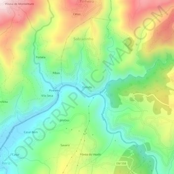
Name: Topografische Karte Ermida, Höhe, Relief.
Ort: Ermida, Picão e Ermida, Castro Daire, Viseu, Portugal (40.90125 -7.98812 40.94125 -7.94812)
Durchschnittliche Höhe: 554 m
Minimale Höhe: 288 m
Maximale Höhe: 978 m
Andere topografische Karten
Klicken Sie auf eine Karte, um ihre Topografie, ihre Höhe und ihr Relief anzuzeigen.
Mezio
Portugal > Viseu > Castro Daire
Mezio, Castro Daire, Viseu, Portugal
Durchschnittliche Höhe: 969 m
Cêtos
Portugal > Viseu > Castro Daire > Pinheiro
Cêtos, Pinheiro, Castro Daire, Viseu, Portugal
Durchschnittliche Höhe: 737 m
Monteiras
Portugal > Viseu > Castro Daire
Monteiras, Castro Daire, Viseu, Portugal
Durchschnittliche Höhe: 898 m
Folgosa
Portugal > Viseu > Castro Daire
Folgosa, Castro Daire, Viseu, 3600-143, Portugal
Durchschnittliche Höhe: 596 m
Gosende
Portugal > Viseu > Castro Daire
Gosende, Castro Daire, Viseu, Portugal
Durchschnittliche Höhe: 1.011 m
Almofala
Portugal > Viseu > Castro Daire
Almofala, Castro Daire, Viseu, 3600-011, Portugal
Durchschnittliche Höhe: 899 m