
Topografische Karte Kavaratti Island
Interaktive Karte
Klicken Sie auf die Karte, um die Höhe anzuzeigen.
Über diese Karte
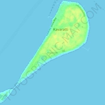
Name: Topografische Karte Kavaratti Island, Höhe, Relief.
Ort: Kavaratti Island, Kavaratti, Lakshadweep, 262240, India (10.54073 72.61545 10.57747 72.64979)
Durchschnittliche Höhe: 2 m
Minimale Höhe: 0 m
Maximale Höhe: 17 m
The island of Kavaratti lies 360 km (190 nmi) off the coast of the state of Kerala at 10°34′N 72°38′E / 10.57°N 72.64°E / 10.57; 72.64. It has an average elevation of 0 metres (0 feet).