
Topografische Karte Bandon
Interaktive Karte
Klicken Sie auf die Karte, um die Höhe anzuzeigen.
Über diese Karte
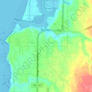
Name: Topografische Karte Bandon, Höhe, Relief.
Ort: Bandon, Coos County, Oregon, United States (43.08954 -124.43730 43.13370 -124.39402)
Durchschnittliche Höhe: 22 m
Minimale Höhe: -1 m
Maximale Höhe: 75 m
Andere topografische Karten
Klicken Sie auf eine Karte, um ihre Topografie, ihre Höhe und ihr Relief anzuzeigen.
Whiskey Run Beach
United States > Oregon > Coos County
Whiskey Run Beach, Coos County, Oregon, United States
Durchschnittliche Höhe: 22 m
Coquille
United States > Oregon > Coos County
Coquille, Coos County, Oregon, United States
Durchschnittliche Höhe: 40 m
North Bend
United States > Oregon > Coos County > North Bend
North Bend, Coos County, Oregon, United States
Durchschnittliche Höhe: 11 m
Coos Bay
United States > Oregon > Coos County
Coos Bay, Coos County, Oregon, 97420, United States
Durchschnittliche Höhe: 30 m