
Topografische Karte Deep Creek
Interaktive Karte
Klicken Sie auf die Karte, um die Höhe anzuzeigen.
Über diese Karte
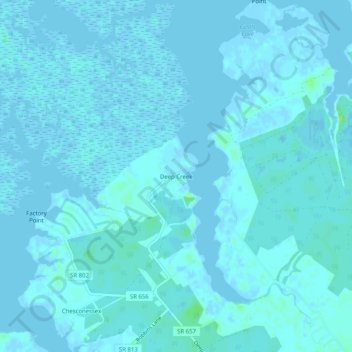
Name: Topografische Karte Deep Creek, Höhe, Relief.
Ort: Deep Creek, Accomack County, Virginia, United States (37.74735 -75.77271 37.78735 -75.73271)
Durchschnittliche Höhe: 1 m
Minimale Höhe: -5 m
Maximale Höhe: 12 m
Andere topografische Karten
Klicken Sie auf eine Karte, um ihre Topografie, ihre Höhe und ihr Relief anzuzeigen.
Assawoman Island
United States > Virginia > Accomack County
Assawoman Island, Accomack County, Virginia, United States
Durchschnittliche Höhe: 2 m
Upper Tump
United States > Virginia > Accomack County
Upper Tump, Accomack County, Virginia, United States
Durchschnittliche Höhe: 0 m
Onancock
United States > Virginia > Accomack County
Onancock, Accomack County, Virginia, United States
Durchschnittliche Höhe: 6 m
McClean Gut
United States > Virginia > Accomack County > Cedar View
McClean Gut, Cedar View, Accomack County, Virginia, United States
Durchschnittliche Höhe: 2 m
Tangier
United States > Virginia > Accomack County > Tangier
Tangier, Accomack County, Virginia, 23440, United States
Durchschnittliche Höhe: 0 m
Painter
United States > Virginia > Accomack County
Painter, Accomack County, Virginia, United States
Durchschnittliche Höhe: 10 m