Topografische Karte Kap-Breton-Insel
Klicken Sie auf die Karte, um die Höhe anzuzeigen.
Über diese Karte

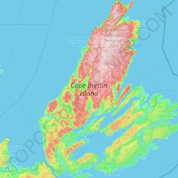
Name: Topografische Karte Kap-Breton-Insel, Höhe, Relief.
Ort: Kap-Breton-Insel, Neuschottland, Kanada (45.54803 -61.55268 47.04205 -59.78811)
Durchschnittliche Höhe: 66 m
Minimale Höhe: -3 m
Maximale Höhe: 531 m
Andere topografische Karten
Klicken Sie auf eine Karte, um ihre Topografie, ihre Höhe und ihr Relief anzuzeigen.

O'Neils Point
Kanada > Neuschottland > Cape Breton Regional Municipality > Glace Bay
O'Neils Point, Glace Bay, Cape Breton Regional Municipality, Cape Breton County, Neuschottland, B1A 6E9, Kanada
Durchschnittliche Höhe: 8 m

Christmas Island
Kanada > Neuschottland > Cape Breton Regional Municipality
Christmas Island, Cape Breton Regional Municipality, Cape Breton County, Neuschottland, Kanada
Durchschnittliche Höhe: 25 m

Long Point
Long Point, Municipality of the County of Inverness, Inverness County, Neuschottland, Kanada
Durchschnittliche Höhe: 85 m

St. Marys River
St. Marys River, St. Mary's District Municipality, Guysborough County, Neuschottland, Kanada
Durchschnittliche Höhe: 27 m

Trafalgar
Trafalgar, Halifax Regional Municipality, Halifax County, Neuschottland, Kanada
Durchschnittliche Höhe: 148 m

Waldeck
Waldeck, Municipality of the County of Annapolis, Annapolis County, Neuschottland, B0S 1J0, Kanada
Durchschnittliche Höhe: 128 m

Grand Lake
Grand Lake, Halifax Regional Municipality, Halifax County, Neuschottland, Kanada
Durchschnittliche Höhe: 56 m

Bras d'Or Lake
Kanada > Neuschottland > Potlotek First Nation
Bras d'Or Lake, Chapel Island 7 Trail, Chapel Island 5, Potlotek First Nation, Richmond County, Neuschottland, B0E 3B0, Kanada
Durchschnittliche Höhe: 0 m