
Topografische Karte Kozłowiec
Interaktive Karte
Klicken Sie auf die Karte, um die Höhe anzuzeigen.
Über diese Karte
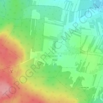
Name: Topografische Karte Kozłowiec, Höhe, Relief.
Durchschnittliche Höhe: 264 m
Minimale Höhe: 217 m
Maximale Höhe: 333 m
Andere topografische Karten
Klicken Sie auf eine Karte, um ihre Topografie, ihre Höhe und ihr Relief anzuzeigen.
Wysokin
Poland > Masovian Voivodeship > Przysucha County
Wysokin, gmina Odrzywół, Przysucha County, Masovian Voivodeship, 26-425, Poland
Durchschnittliche Höhe: 152 m
Podczasza Wola
Poland > Masovian Voivodeship > Przysucha County
Podczasza Wola, gmina Klwów, Przysucha County, Masovian Voivodeship, Poland
Durchschnittliche Höhe: 168 m
Przysucha
Poland > Masovian Voivodeship > Przysucha County > Przysucha > Przysucha
Przysucha, gmina Przysucha, Przysucha County, Masovian Voivodeship, 26-400, Poland
Durchschnittliche Höhe: 227 m
Ruski Bród
Poland > Masovian Voivodeship > Przysucha County
Ruski Bród, gmina Przysucha, Przysucha County, Masovian Voivodeship, Poland
Durchschnittliche Höhe: 269 m