
Topografische Karte Worcester
Interaktive Karte
Klicken Sie auf die Karte, um die Höhe anzuzeigen.
Über diese Karte
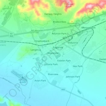
Name: Topografische Karte Worcester, Höhe, Relief.
Durchschnittliche Höhe: 252 m
Minimale Höhe: 195 m
Maximale Höhe: 525 m
Worcester is located at an elevation of 220 metres (720 ft) and can be reached by road either travelling on the N1 highway through the Huguenot Tunnel or by driving through spectacular mountain passes. From Cape Town Du Toitskloof, from Wellington Bainskloof, from Malmesbury, Western Cape Nieuwekloof, from Ceres Mitchells, from Robertson Goree, from Hermanus Rooihoogte and from Johannesburg Hex River, with vistas over the Hex River Valley.
Andere topografische Karten
Klicken Sie auf eine Karte, um ihre Topografie, ihre Höhe und ihr Relief anzuzeigen.
Baboon Peak
South Africa > Western Cape > Cape Winelands District Municipality > Breede Valley Local Municipality
Baboon Peak, Breede Valley Local Municipality, Cape Winelands District Municipality, Western Cape, South Africa
Durchschnittliche Höhe: 1.130 m
Du Toit's Peak
South Africa > Western Cape > Cape Winelands District Municipality > Breede Valley Local Municipality
Du Toit's Peak, Breede Valley Local Municipality, Cape Winelands District Municipality, Western Cape, South Africa
Durchschnittliche Höhe: 1.557 m