
Topografische Karte Orosi
Interaktive Karte
Klicken Sie auf die Karte, um die Höhe anzuzeigen.
Über diese Karte
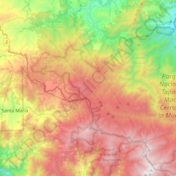
Name: Topografische Karte Orosi, Höhe, Relief.
Ort: Orosi, Cantón Paraíso, Cartago Province, 30203, Costa Rica (9.55111 -83.87548 9.82417 -83.62702)
Durchschnittliche Höhe: 2.036 m
Minimale Höhe: 706 m
Maximale Höhe: 3.472 m
Orosi has an area of 376.41 km2 (145.33 sq mi)[5] and an elevation of 1,051 m (3,448 ft).[1]
Andere topografische Karten
Klicken Sie auf eine Karte, um ihre Topografie, ihre Höhe und ihr Relief anzuzeigen.
Parque Nacional Tapantí - Macizo Cerro de la Muerte
Parque Nacional Tapantí - Macizo Cerro de la Muerte, Cantón Paraíso, Cartago Province, Costa Rica
Durchschnittliche Höhe: 1.837 m
Cachí
Cachí, Cantón Paraíso, Cartago Province, 30204, Costa Rica
Durchschnittliche Höhe: 1.254 m
Santiago
Santiago, Cantón Paraíso, Cartago Province, 30202, Costa Rica
Durchschnittliche Höhe: 1.275 m